You are here: Home > Network List > TA - USArray Transportable Network (new EarthScope stations) Stations List
> Station G14A Jackson, MT, USA > Earthquake Result Viewer
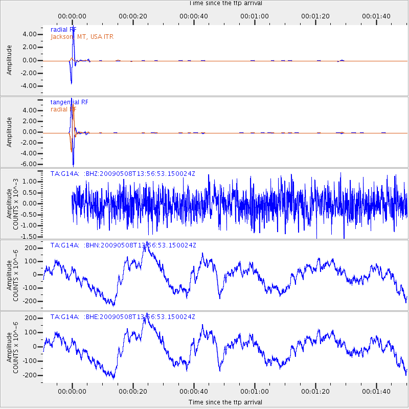
G14A Jackson, MT, USA - Earthquake Result Viewer
*The percent match for this event was below the threshold and hence no stack was calculated.
| Earthquake location: |
Mendoza Province, Argentina |
| Earthquake latitude/longitude: |
-32.1/-69.7 |
| Earthquake time(UTC): |
2009/05/08 (128) 13:44:53 GMT |
| Earthquake Depth: |
112 km |
| Earthquake Magnitude: |
5.6 MB, 5.4 MW |
| Earthquake Catalog/Contributor: |
WHDF/NEIC |
|
| Network: |
TA USArray Transportable Network (new EarthScope stations) |
| Station: |
G14A Jackson, MT, USA |
| Lat/Lon: |
45.24 N/113.46 W |
| Elevation: |
2140 m |
|
| Distance: |
86.6 deg |
| Az: |
330.68 deg |
| Baz: |
143.945 deg |
| Ray Param: |
$rayparam |
*The percent match for this event was below the threshold and hence was not used in the summary stack. |
|
| Radial Match: |
87.92671 % |
| Radial Bump: |
400 |
| Transverse Match: |
87.89376 % |
| Transverse Bump: |
400 |
| SOD ConfigId: |
2658 |
| Insert Time: |
2010-03-06 05:07:48.284 +0000 |
| GWidth: |
2.5 |
| Max Bumps: |
400 |
| Tol: |
0.001 |
|
Signal To Noise
| Channel | StoN | STA | LTA |
| TA:G14A: :BHN:20090508T13:56:53.150024Z | 0.7768717 | 6.88643E-5 | 8.8643086E-5 |
| TA:G14A: :BHE:20090508T13:56:53.150024Z | 0.77564305 | 6.518386E-5 | 8.403848E-5 |
| TA:G14A: :BHZ:20090508T13:56:53.150024Z | 0.9450171 | 4.2081074E-4 | 4.452943E-4 |
| Arrivals |
| Ps | |
| PpPs | |
| PsPs/PpSs | |


