You are here: Home > Network List > TA - USArray Transportable Network (new EarthScope stations) Stations List
> Station G14A Jackson, MT, USA > Earthquake Result Viewer
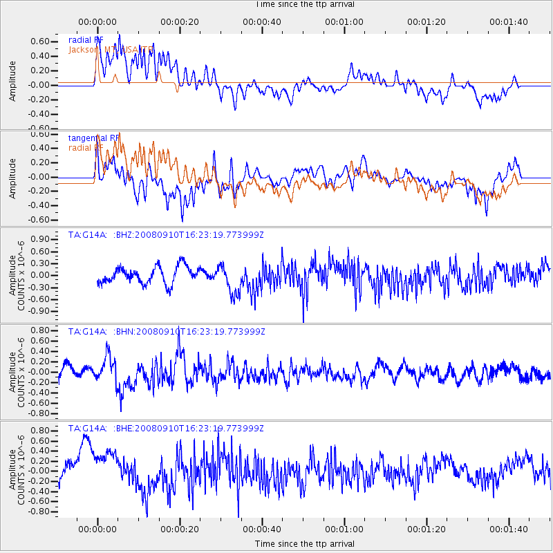
G14A Jackson, MT, USA - Earthquake Result Viewer
*The percent match for this event was below the threshold and hence no stack was calculated.
| Earthquake location: |
Northern Chile |
| Earthquake latitude/longitude: |
-20.3/-69.2 |
| Earthquake time(UTC): |
2008/09/10 (254) 16:12:04 GMT |
| Earthquake Depth: |
38 km |
| Earthquake Magnitude: |
5.6 MB, 5.3 MS |
| Earthquake Catalog/Contributor: |
WHDF/NEIC |
|
| Network: |
TA USArray Transportable Network (new EarthScope stations) |
| Station: |
G14A Jackson, MT, USA |
| Lat/Lon: |
45.24 N/113.46 W |
| Elevation: |
2140 m |
|
| Distance: |
76.6 deg |
| Az: |
329.561 deg |
| Baz: |
137.68 deg |
| Ray Param: |
$rayparam |
*The percent match for this event was below the threshold and hence was not used in the summary stack. |
|
| Radial Match: |
66.24431 % |
| Radial Bump: |
400 |
| Transverse Match: |
65.41972 % |
| Transverse Bump: |
400 |
| SOD ConfigId: |
2560 |
| Insert Time: |
2010-03-06 05:07:59.450 +0000 |
| GWidth: |
2.5 |
| Max Bumps: |
400 |
| Tol: |
0.001 |
|
Signal To Noise
| Channel | StoN | STA | LTA |
| TA:G14A: :BHN:20080910T16:23:19.773999Z | 1.9223888 | 2.6344898E-7 | 1.370425E-7 |
| TA:G14A: :BHE:20080910T16:23:19.773999Z | 1.8998979 | 4.5018783E-7 | 2.3695368E-7 |
| TA:G14A: :BHZ:20080910T16:23:19.773999Z | 1.8342388 | 3.8041907E-7 | 2.0739887E-7 |
| Arrivals |
| Ps | |
| PpPs | |
| PsPs/PpSs | |


