You are here: Home > Network List > KS - Korea National Seismograph Network- KMA Stations List
> Station CHJ2 Chungju, South Korea > Earthquake Result Viewer
CHJ2 Chungju, South Korea - Earthquake Result Viewer
| Earthquake location: |
Rat Islands, Aleutian Islands |
| Earthquake latitude/longitude: |
52.4/176.8 |
| Earthquake time(UTC): |
2017/10/08 (281) 22:34:33 GMT |
| Earthquake Depth: |
112 km |
| Earthquake Magnitude: |
6.6 mww |
| Earthquake Catalog/Contributor: |
NEIC PDE/us |
|
| Network: |
KS Korea National Seismograph Network- KMA |
| Station: |
CHJ2 Chungju, South Korea |
| Lat/Lon: |
36.87 N/127.97 E |
| Elevation: |
217 m |
|
| Distance: |
37.3 deg |
| Az: |
265.098 deg |
| Baz: |
49.503 deg |
| Ray Param: |
0.07583713 |
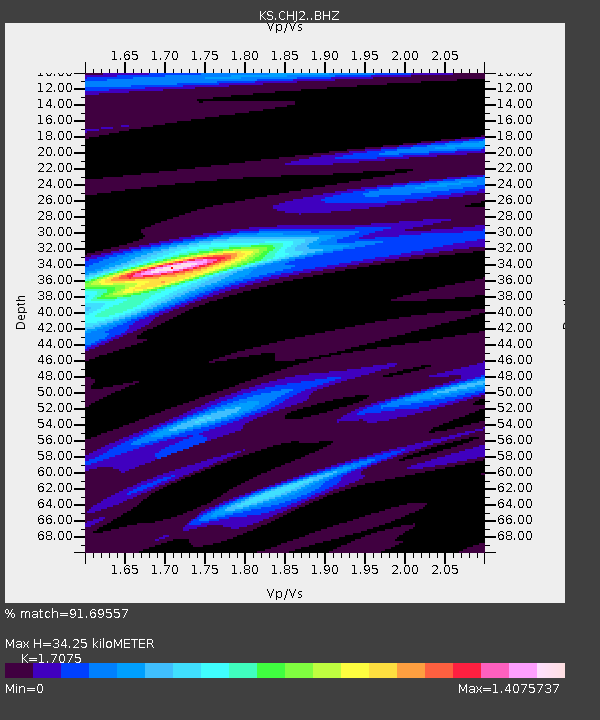
| Estimated Moho Depth: |
34.25 km |
| Estimated Crust Vp/Vs: |
1.71 |
| Assumed Crust Vp: |
6.459 km/s |
| Estimated Crust Vs: |
3.783 km/s |
| Estimated Crust Poisson's Ratio: |
0.24 |
|
| Radial Match: |
91.69557 % |
| Radial Bump: |
271 |
| Transverse Match: |
83.5371 % |
| Transverse Bump: |
400 |
| SOD ConfigId: |
13570011 |
| Insert Time: |
2019-04-28 23:14:29.790 +0000 |
| GWidth: |
2.5 |
| Max Bumps: |
400 |
| Tol: |
0.001 |
|

Signal To Noise
| Channel | StoN | STA | LTA |
| KS:CHJ2: :BHZ:20171008T22:41:04.819009Z | 32.801533 | 3.2210041E-6 | 9.819675E-8 |
| KS:CHJ2: :BHN:20171008T22:41:04.819009Z | 18.51768 | 1.1335253E-6 | 6.1213136E-8 |
| KS:CHJ2: :BHE:20171008T22:41:04.819009Z | 27.56651 | 1.5809378E-6 | 5.7349943E-8 |
| Arrivals |
| Ps | 4.1 SECOND |
| PpPs | 13 SECOND |
| PsPs/PpSs | 17 SECOND |


