You are here: Home > Network List > TA - USArray Transportable Network (new EarthScope stations) Stations List
> Station G14A Jackson, MT, USA > Earthquake Result Viewer
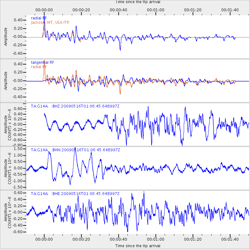
G14A Jackson, MT, USA - Earthquake Result Viewer
*The percent match for this event was below the threshold and hence no stack was calculated.
| Earthquake location: |
Kermadec Islands Region |
| Earthquake latitude/longitude: |
-31.5/-178.8 |
| Earthquake time(UTC): |
2009/05/16 (136) 00:53:52 GMT |
| Earthquake Depth: |
55 km |
| Earthquake Magnitude: |
6.1 MB, 6.5 MW, 6.3 MW |
| Earthquake Catalog/Contributor: |
WHDF/NEIC |
|
| Network: |
TA USArray Transportable Network (new EarthScope stations) |
| Station: |
G14A Jackson, MT, USA |
| Lat/Lon: |
45.24 N/113.46 W |
| Elevation: |
2140 m |
|
| Distance: |
96.7 deg |
| Az: |
40.27 deg |
| Baz: |
231.388 deg |
| Ray Param: |
$rayparam |
*The percent match for this event was below the threshold and hence was not used in the summary stack. |
|
| Radial Match: |
74.26422 % |
| Radial Bump: |
400 |
| Transverse Match: |
74.44908 % |
| Transverse Bump: |
400 |
| SOD ConfigId: |
2760 |
| Insert Time: |
2010-03-06 05:08:07.107 +0000 |
| GWidth: |
2.5 |
| Max Bumps: |
400 |
| Tol: |
0.001 |
|
Signal To Noise
| Channel | StoN | STA | LTA |
| TA:G14A: :BHN:20090516T01:06:45.648997Z | 6.692875 | 6.698001E-7 | 1.0007659E-7 |
| TA:G14A: :BHE:20090516T01:06:45.648997Z | 0.8524879 | 8.8761254E-8 | 1.04120254E-7 |
| TA:G14A: :BHZ:20090516T01:06:45.648997Z | 1.4955544 | 2.1726737E-7 | 1.4527546E-7 |
| Arrivals |
| Ps | |
| PpPs | |
| PsPs/PpSs | |


