You are here: Home > Network List > LD - Lamont-Doherty Cooperative Seismographic Network Stations List
> Station GEDE Greenville, DE, USA > Earthquake Result Viewer
GEDE Greenville, DE, USA - Earthquake Result Viewer
| Earthquake location: |
Rat Islands, Aleutian Islands |
| Earthquake latitude/longitude: |
52.4/176.8 |
| Earthquake time(UTC): |
2017/10/08 (281) 22:34:33 GMT |
| Earthquake Depth: |
112 km |
| Earthquake Magnitude: |
6.6 mww |
| Earthquake Catalog/Contributor: |
NEIC PDE/us |
|
| Network: |
LD Lamont-Doherty Cooperative Seismographic Network |
| Station: |
GEDE Greenville, DE, USA |
| Lat/Lon: |
39.81 N/75.64 W |
| Elevation: |
105 m |
|
| Distance: |
68.8 deg |
| Az: |
51.986 deg |
| Baz: |
321.244 deg |
| Ray Param: |
0.055799134 |
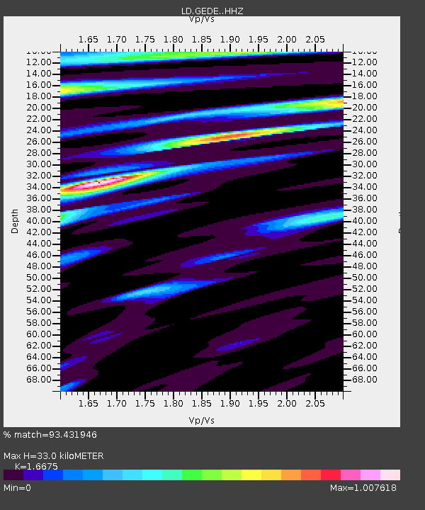
| Estimated Moho Depth: |
33.0 km |
| Estimated Crust Vp/Vs: |
1.67 |
| Assumed Crust Vp: |
6.287 km/s |
| Estimated Crust Vs: |
3.771 km/s |
| Estimated Crust Poisson's Ratio: |
0.22 |
|
| Radial Match: |
93.431946 % |
| Radial Bump: |
321 |
| Transverse Match: |
73.01993 % |
| Transverse Bump: |
400 |
| SOD ConfigId: |
13570011 |
| Insert Time: |
2019-04-28 23:14:52.334 +0000 |
| GWidth: |
2.5 |
| Max Bumps: |
400 |
| Tol: |
0.001 |
|

Signal To Noise
| Channel | StoN | STA | LTA |
| LD:GEDE: :HHZ:20171008T22:44:55.079995Z | 27.78036 | 4.290848E-6 | 1.5445619E-7 |
| LD:GEDE: :HHN:20171008T22:44:55.079995Z | 12.344607 | 1.2256162E-6 | 9.9283525E-8 |
| LD:GEDE: :HHE:20171008T22:44:55.079995Z | 5.2306557 | 7.5113223E-7 | 1.4360192E-7 |
| Arrivals |
| Ps | 3.6 SECOND |
| PpPs | 13 SECOND |
| PsPs/PpSs | 17 SECOND |


