You are here: Home > Network List > TA - USArray Transportable Network (new EarthScope stations) Stations List
> Station G14A Jackson, MT, USA > Earthquake Result Viewer
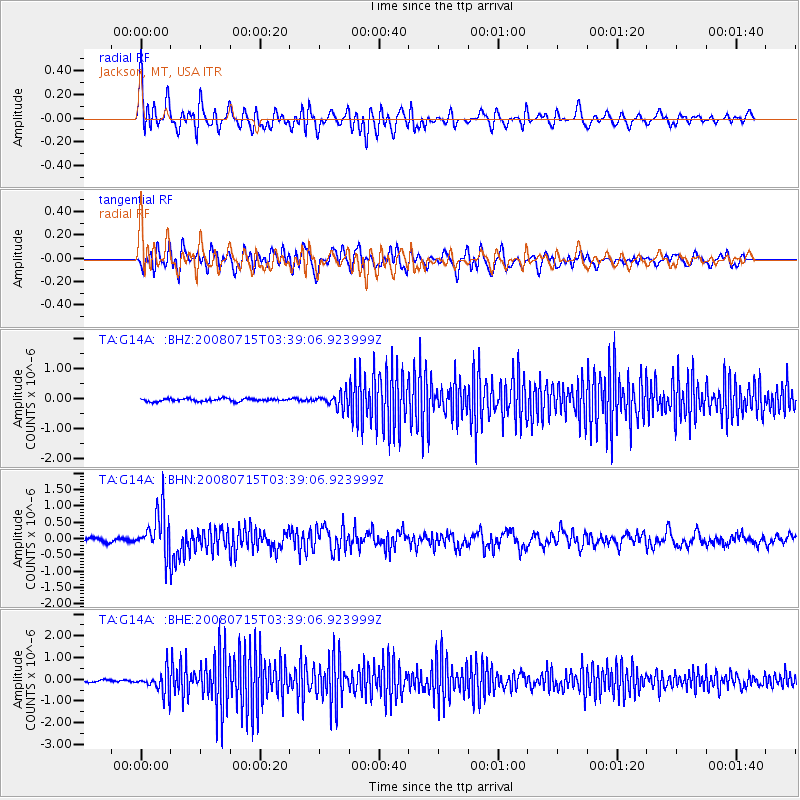
G14A Jackson, MT, USA - Earthquake Result Viewer
*The percent match for this event was below the threshold and hence no stack was calculated.
| Earthquake location: |
Dodecanese Islands, Greece |
| Earthquake latitude/longitude: |
35.8/27.9 |
| Earthquake time(UTC): |
2008/07/15 (197) 03:26:34 GMT |
| Earthquake Depth: |
52 km |
| Earthquake Magnitude: |
6.5 MB, 6.4 MW, 6.4 MW |
| Earthquake Catalog/Contributor: |
WHDF/NEIC |
|
| Network: |
TA USArray Transportable Network (new EarthScope stations) |
| Station: |
G14A Jackson, MT, USA |
| Lat/Lon: |
45.24 N/113.46 W |
| Elevation: |
2140 m |
|
| Distance: |
92.1 deg |
| Az: |
333.78 deg |
| Baz: |
30.556 deg |
| Ray Param: |
$rayparam |
*The percent match for this event was below the threshold and hence was not used in the summary stack. |
|
| Radial Match: |
68.442215 % |
| Radial Bump: |
400 |
| Transverse Match: |
64.159195 % |
| Transverse Bump: |
400 |
| SOD ConfigId: |
2504 |
| Insert Time: |
2010-03-06 05:08:12.302 +0000 |
| GWidth: |
2.5 |
| Max Bumps: |
400 |
| Tol: |
0.001 |
|
Signal To Noise
| Channel | StoN | STA | LTA |
| TA:G14A: :BHN:20080715T03:39:06.923999Z | 12.877275 | 6.6849407E-7 | 5.1912696E-8 |
| TA:G14A: :BHE:20080715T03:39:06.923999Z | 8.5285015 | 5.172928E-7 | 6.06546E-8 |
| TA:G14A: :BHZ:20080715T03:39:06.923999Z | 4.9963193 | 2.3925642E-7 | 4.7886537E-8 |
| Arrivals |
| Ps | |
| PpPs | |
| PsPs/PpSs | |


