You are here: Home > Network List > N4 - Central and EAstern US Network Stations List
> Station N35B Tabor, IA, USA > Earthquake Result Viewer
N35B Tabor, IA, USA - Earthquake Result Viewer
| Earthquake location: |
Rat Islands, Aleutian Islands |
| Earthquake latitude/longitude: |
52.4/176.8 |
| Earthquake time(UTC): |
2017/10/08 (281) 22:34:33 GMT |
| Earthquake Depth: |
112 km |
| Earthquake Magnitude: |
6.6 mww |
| Earthquake Catalog/Contributor: |
NEIC PDE/us |
|
| Network: |
N4 Central and EAstern US Network |
| Station: |
N35B Tabor, IA, USA |
| Lat/Lon: |
40.86 N/95.64 W |
| Elevation: |
353 m |
|
| Distance: |
57.6 deg |
| Az: |
63.778 deg |
| Baz: |
313.623 deg |
| Ray Param: |
0.06302949 |
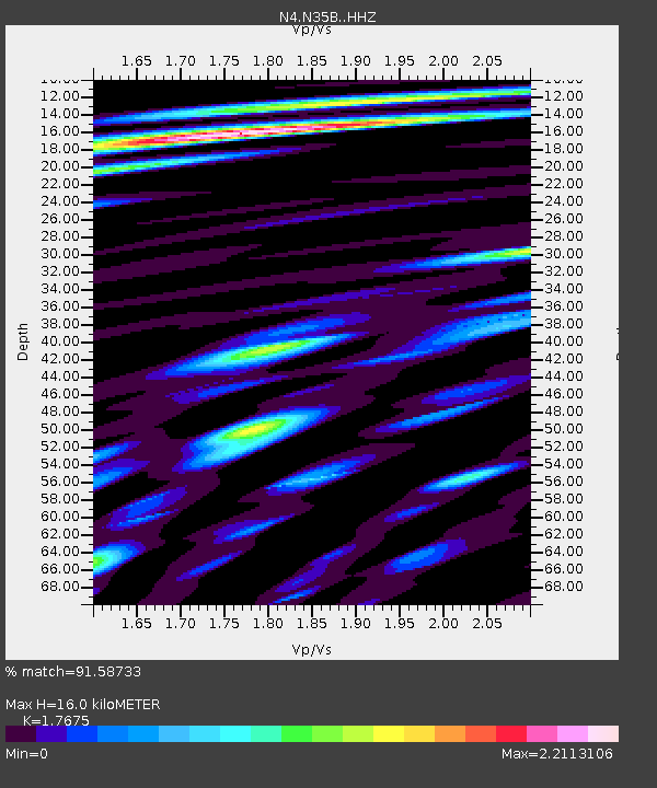
| Estimated Moho Depth: |
16.0 km |
| Estimated Crust Vp/Vs: |
1.77 |
| Assumed Crust Vp: |
6.498 km/s |
| Estimated Crust Vs: |
3.676 km/s |
| Estimated Crust Poisson's Ratio: |
0.26 |
|
| Radial Match: |
91.58733 % |
| Radial Bump: |
400 |
| Transverse Match: |
78.74289 % |
| Transverse Bump: |
400 |
| SOD ConfigId: |
13570011 |
| Insert Time: |
2019-04-28 23:16:25.261 +0000 |
| GWidth: |
2.5 |
| Max Bumps: |
400 |
| Tol: |
0.001 |
|

Signal To Noise
| Channel | StoN | STA | LTA |
| N4:N35B: :HHZ:20171008T22:43:41.809976Z | 61.053047 | 1.1714774E-5 | 1.918786E-7 |
| N4:N35B: :HHN:20171008T22:43:41.809976Z | 39.624157 | 6.787527E-6 | 1.712977E-7 |
| N4:N35B: :HHE:20171008T22:43:41.809976Z | 24.586342 | 4.8713246E-6 | 1.9813135E-7 |
| Arrivals |
| Ps | 2.0 SECOND |
| PpPs | 6.5 SECOND |
| PsPs/PpSs | 8.5 SECOND |


