You are here: Home > Network List > N4 - Central and EAstern US Network Stations List
> Station Q51A Peebles, OH, USA > Earthquake Result Viewer
Q51A Peebles, OH, USA - Earthquake Result Viewer
| Earthquake location: |
Rat Islands, Aleutian Islands |
| Earthquake latitude/longitude: |
52.4/176.8 |
| Earthquake time(UTC): |
2017/10/08 (281) 22:34:33 GMT |
| Earthquake Depth: |
112 km |
| Earthquake Magnitude: |
6.6 mww |
| Earthquake Catalog/Contributor: |
NEIC PDE/us |
|
| Network: |
N4 Central and EAstern US Network |
| Station: |
Q51A Peebles, OH, USA |
| Lat/Lon: |
39.03 N/83.35 W |
| Elevation: |
362 m |
|
| Distance: |
65.5 deg |
| Az: |
57.487 deg |
| Baz: |
318.502 deg |
| Ray Param: |
0.0579171 |
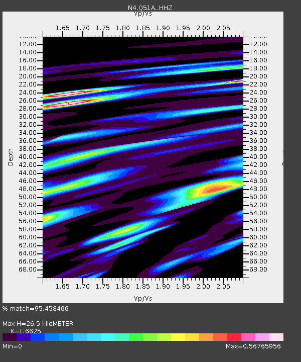
| Estimated Moho Depth: |
26.5 km |
| Estimated Crust Vp/Vs: |
1.66 |
| Assumed Crust Vp: |
6.232 km/s |
| Estimated Crust Vs: |
3.748 km/s |
| Estimated Crust Poisson's Ratio: |
0.22 |
|
| Radial Match: |
95.458466 % |
| Radial Bump: |
400 |
| Transverse Match: |
81.06528 % |
| Transverse Bump: |
400 |
| SOD ConfigId: |
13570011 |
| Insert Time: |
2019-04-28 23:16:45.308 +0000 |
| GWidth: |
2.5 |
| Max Bumps: |
400 |
| Tol: |
0.001 |
|

Signal To Noise
| Channel | StoN | STA | LTA |
| N4:Q51A: :HHZ:20171008T22:44:34.590005Z | 34.36772 | 5.484762E-6 | 1.5959051E-7 |
| N4:Q51A: :HHN:20171008T22:44:34.590005Z | 15.59972 | 2.011011E-6 | 1.2891327E-7 |
| N4:Q51A: :HHE:20171008T22:44:34.590005Z | 13.395898 | 1.8674582E-6 | 1.3940523E-7 |
| Arrivals |
| Ps | 2.9 SECOND |
| PpPs | 11 SECOND |
| PsPs/PpSs | 14 SECOND |


