You are here: Home > Network List > TA - USArray Transportable Network (new EarthScope stations) Stations List
> Station G14A Jackson, MT, USA > Earthquake Result Viewer
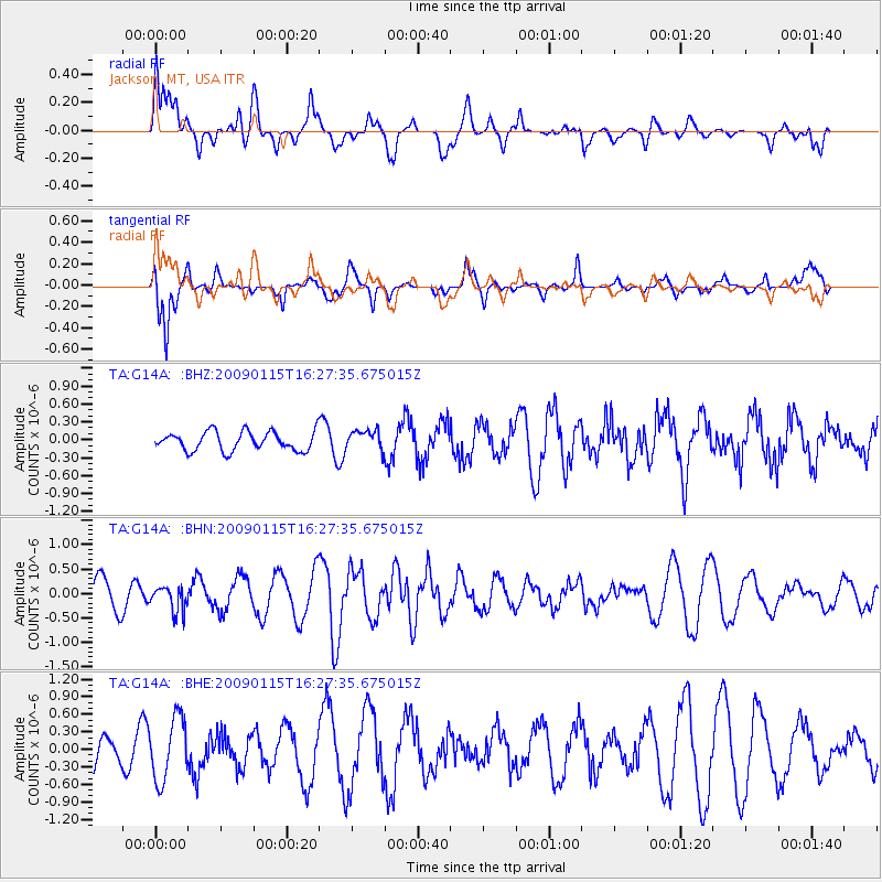
G14A Jackson, MT, USA - Earthquake Result Viewer
*The percent match for this event was below the threshold and hence no stack was calculated.
| Earthquake location: |
Solomon Islands |
| Earthquake latitude/longitude: |
-10.3/161.2 |
| Earthquake time(UTC): |
2009/01/15 (015) 16:15:01 GMT |
| Earthquake Depth: |
114 km |
| Earthquake Magnitude: |
5.6 MB, 5.7 MW, 5.7 MW |
| Earthquake Catalog/Contributor: |
WHDF/NEIC |
|
| Network: |
TA USArray Transportable Network (new EarthScope stations) |
| Station: |
G14A Jackson, MT, USA |
| Lat/Lon: |
45.24 N/113.46 W |
| Elevation: |
2140 m |
|
| Distance: |
94.0 deg |
| Az: |
44.898 deg |
| Baz: |
259.451 deg |
| Ray Param: |
$rayparam |
*The percent match for this event was below the threshold and hence was not used in the summary stack. |
|
| Radial Match: |
50.75621 % |
| Radial Bump: |
400 |
| Transverse Match: |
76.38362 % |
| Transverse Bump: |
400 |
| SOD ConfigId: |
2834 |
| Insert Time: |
2010-03-06 05:08:57.734 +0000 |
| GWidth: |
2.5 |
| Max Bumps: |
400 |
| Tol: |
0.001 |
|
Signal To Noise
| Channel | StoN | STA | LTA |
| TA:G14A: :BHN:20090115T16:27:35.675015Z | 0.8349918 | 2.5305016E-7 | 3.0305705E-7 |
| TA:G14A: :BHE:20090115T16:27:35.675015Z | 2.17013 | 5.359142E-7 | 2.4695026E-7 |
| TA:G14A: :BHZ:20090115T16:27:35.675015Z | 1.0552858 | 1.6720783E-7 | 1.584479E-7 |
| Arrivals |
| Ps | |
| PpPs | |
| PsPs/PpSs | |


