You are here: Home > Network List > N4 - Central and EAstern US Network Stations List
> Station T60A Surry, VA, USA > Earthquake Result Viewer
T60A Surry, VA, USA - Earthquake Result Viewer
| Earthquake location: |
Rat Islands, Aleutian Islands |
| Earthquake latitude/longitude: |
52.4/176.8 |
| Earthquake time(UTC): |
2017/10/08 (281) 22:34:33 GMT |
| Earthquake Depth: |
112 km |
| Earthquake Magnitude: |
6.6 mww |
| Earthquake Catalog/Contributor: |
NEIC PDE/us |
|
| Network: |
N4 Central and EAstern US Network |
| Station: |
T60A Surry, VA, USA |
| Lat/Lon: |
37.14 N/76.73 W |
| Elevation: |
11 m |
|
| Distance: |
70.3 deg |
| Az: |
54.484 deg |
| Baz: |
321.435 deg |
| Ray Param: |
0.05478037 |
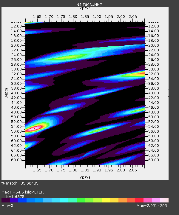
| Estimated Moho Depth: |
54.5 km |
| Estimated Crust Vp/Vs: |
1.64 |
| Assumed Crust Vp: |
6.565 km/s |
| Estimated Crust Vs: |
4.009 km/s |
| Estimated Crust Poisson's Ratio: |
0.20 |
|
| Radial Match: |
85.60485 % |
| Radial Bump: |
400 |
| Transverse Match: |
78.432915 % |
| Transverse Bump: |
400 |
| SOD ConfigId: |
13570011 |
| Insert Time: |
2019-04-28 23:17:02.693 +0000 |
| GWidth: |
2.5 |
| Max Bumps: |
400 |
| Tol: |
0.001 |
|

Signal To Noise
| Channel | StoN | STA | LTA |
| N4:T60A: :HHZ:20171008T22:45:04.540017Z | 19.611418 | 3.747342E-6 | 1.910796E-7 |
| N4:T60A: :HHN:20171008T22:45:04.540017Z | 5.077151 | 1.6250815E-6 | 3.2007745E-7 |
| N4:T60A: :HHE:20171008T22:45:04.540017Z | 5.2937026 | 1.6121458E-6 | 3.045403E-7 |
| Arrivals |
| Ps | 5.5 SECOND |
| PpPs | 21 SECOND |
| PsPs/PpSs | 27 SECOND |


