You are here: Home > Network List > BK - Berkeley Digital Seismograph Network Stations List
> Station HUMO Hull Mountain, OR > Earthquake Result Viewer
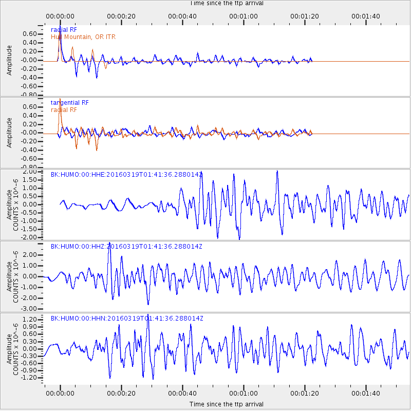
HUMO Hull Mountain, OR - Earthquake Result Viewer
*The percent match for this event was below the threshold and hence no stack was calculated.
| Earthquake location: |
Andreanof Islands, Aleutian Is. |
| Earthquake latitude/longitude: |
51.5/-174.2 |
| Earthquake time(UTC): |
2016/03/19 (079) 01:35:12 GMT |
| Earthquake Depth: |
17 km |
| Earthquake Magnitude: |
6.0 MWW, 5.5 ML, 5.8 MWB |
| Earthquake Catalog/Contributor: |
NEIC PDE/NEIC COMCAT |
|
| Network: |
BK Berkeley Digital Seismograph Network |
| Station: |
HUMO Hull Mountain, OR |
| Lat/Lon: |
42.61 N/122.96 W |
| Elevation: |
555 m |
|
| Distance: |
35.4 deg |
| Az: |
83.96 deg |
| Baz: |
302.676 deg |
| Ray Param: |
$rayparam |
*The percent match for this event was below the threshold and hence was not used in the summary stack. |
|
| Radial Match: |
79.62282 % |
| Radial Bump: |
308 |
| Transverse Match: |
75.36097 % |
| Transverse Bump: |
400 |
| SOD ConfigId: |
1464191 |
| Insert Time: |
2016-04-02 01:56:21.598 +0000 |
| GWidth: |
2.5 |
| Max Bumps: |
400 |
| Tol: |
0.001 |
|
Signal To Noise
| Channel | StoN | STA | LTA |
| BK:HUMO:00:HHZ:20160319T01:41:36.288014Z | 2.6687555 | 5.0611317E-7 | 1.8964388E-7 |
| BK:HUMO:00:HHN:20160319T01:41:36.288014Z | 0.9741044 | 1.6555822E-7 | 1.6995942E-7 |
| BK:HUMO:00:HHE:20160319T01:41:36.288014Z | 1.2218368 | 2.166567E-7 | 1.7732049E-7 |
| Arrivals |
| Ps | |
| PpPs | |
| PsPs/PpSs | |


