You are here: Home > Network List > TA - USArray Transportable Network (new EarthScope stations) Stations List
> Station G14A Jackson, MT, USA > Earthquake Result Viewer
G14A Jackson, MT, USA - Earthquake Result Viewer
*The percent match for this event was below the threshold and hence no stack was calculated.
| Earthquake location: |
Northern Mid-Atlantic Ridge |
| Earthquake latitude/longitude: |
13.4/-44.8 |
| Earthquake time(UTC): |
2008/12/07 (342) 06:23:09 GMT |
| Earthquake Depth: |
10 km |
| Earthquake Magnitude: |
5.6 MB, 5.3 MS, 5.7 MW |
| Earthquake Catalog/Contributor: |
WHDF/NEIC |
|
| Network: |
TA USArray Transportable Network (new EarthScope stations) |
| Station: |
G14A Jackson, MT, USA |
| Lat/Lon: |
45.24 N/113.46 W |
| Elevation: |
2140 m |
|
| Distance: |
65.6 deg |
| Az: |
313.749 deg |
| Baz: |
95.6 deg |
| Ray Param: |
$rayparam |
*The percent match for this event was below the threshold and hence was not used in the summary stack. |
|
| Radial Match: |
65.232735 % |
| Radial Bump: |
400 |
| Transverse Match: |
48.424076 % |
| Transverse Bump: |
400 |
| SOD ConfigId: |
2658 |
| Insert Time: |
2010-03-06 05:09:11.393 +0000 |
| GWidth: |
2.5 |
| Max Bumps: |
400 |
| Tol: |
0.001 |
|
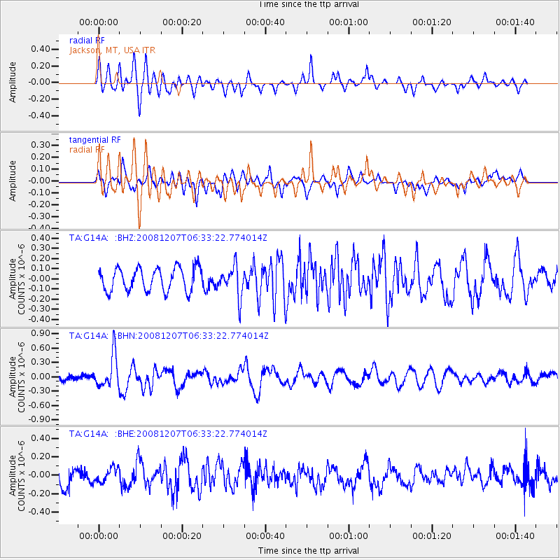
Signal To Noise
| Channel | StoN | STA | LTA |
| TA:G14A: :BHN:20081207T06:33:22.774014Z | 4.1075325 | 3.5421158E-7 | 8.6234635E-8 |
| TA:G14A: :BHE:20081207T06:33:22.774014Z | 0.9131112 | 7.631403E-8 | 8.3575834E-8 |
| TA:G14A: :BHZ:20081207T06:33:22.774014Z | 1.3533123 | 1.5360605E-7 | 1.1350378E-7 |
| Arrivals |
| Ps | |
| PpPs | |
| PsPs/PpSs | |


