You are here: Home > Network List > TA - USArray Transportable Network (new EarthScope stations) Stations List
> Station G14A Jackson, MT, USA > Earthquake Result Viewer
G14A Jackson, MT, USA - Earthquake Result Viewer
*The percent match for this event was below the threshold and hence no stack was calculated.
| Earthquake location: |
Kuril Islands |
| Earthquake latitude/longitude: |
50.8/155.0 |
| Earthquake time(UTC): |
2009/04/21 (111) 05:26:11 GMT |
| Earthquake Depth: |
152 km |
| Earthquake Magnitude: |
6.0 MB, 6.2 MW, 6.2 MW |
| Earthquake Catalog/Contributor: |
WHDF/NEIC |
|
| Network: |
TA USArray Transportable Network (new EarthScope stations) |
| Station: |
G14A Jackson, MT, USA |
| Lat/Lon: |
45.24 N/113.46 W |
| Elevation: |
2140 m |
|
| Distance: |
57.6 deg |
| Az: |
56.729 deg |
| Baz: |
311.369 deg |
| Ray Param: |
$rayparam |
*The percent match for this event was below the threshold and hence was not used in the summary stack. |
|
| Radial Match: |
74.29635 % |
| Radial Bump: |
400 |
| Transverse Match: |
65.994354 % |
| Transverse Bump: |
400 |
| SOD ConfigId: |
2658 |
| Insert Time: |
2010-03-06 05:09:15.549 +0000 |
| GWidth: |
2.5 |
| Max Bumps: |
400 |
| Tol: |
0.001 |
|
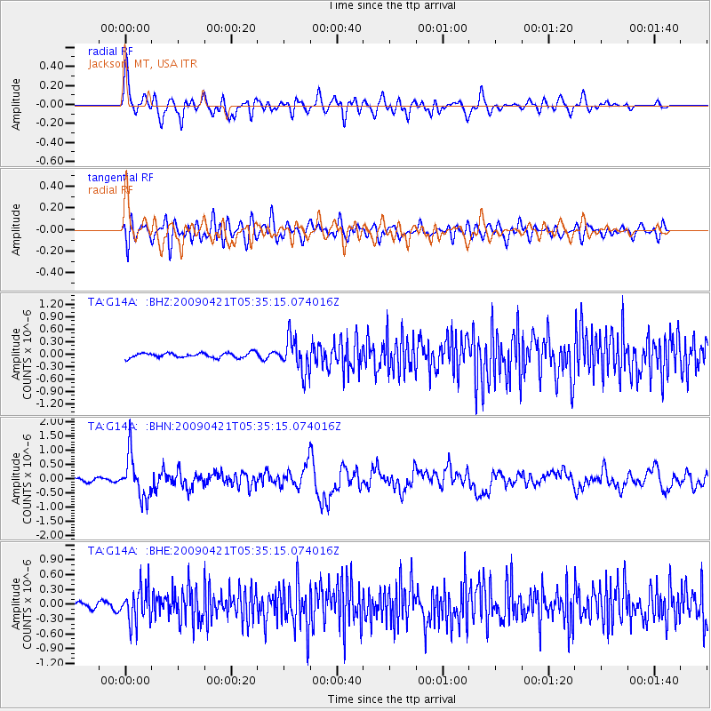
Signal To Noise
| Channel | StoN | STA | LTA |
| TA:G14A: :BHN:20090421T05:35:15.074016Z | 10.21251 | 7.458673E-7 | 7.303467E-8 |
| TA:G14A: :BHE:20090421T05:35:15.074016Z | 6.6321115 | 3.5868533E-7 | 5.4083127E-8 |
| TA:G14A: :BHZ:20090421T05:35:15.074016Z | 6.9223576 | 4.070677E-7 | 5.8804776E-8 |
| Arrivals |
| Ps | |
| PpPs | |
| PsPs/PpSs | |


