You are here: Home > Network List > PS - Pacific21 Stations List
> Station PSI Parapat, Indonesia > Earthquake Result Viewer
PSI Parapat, Indonesia - Earthquake Result Viewer
| Earthquake location: |
Rat Islands, Aleutian Islands |
| Earthquake latitude/longitude: |
52.4/176.8 |
| Earthquake time(UTC): |
2017/10/08 (281) 22:34:33 GMT |
| Earthquake Depth: |
112 km |
| Earthquake Magnitude: |
6.6 mww |
| Earthquake Catalog/Contributor: |
NEIC PDE/us |
|
| Network: |
PS Pacific21 |
| Station: |
PSI Parapat, Indonesia |
| Lat/Lon: |
2.69 N/98.92 E |
| Elevation: |
987 m |
|
| Distance: |
80.5 deg |
| Az: |
262.001 deg |
| Baz: |
37.354 deg |
| Ray Param: |
0.04799295 |
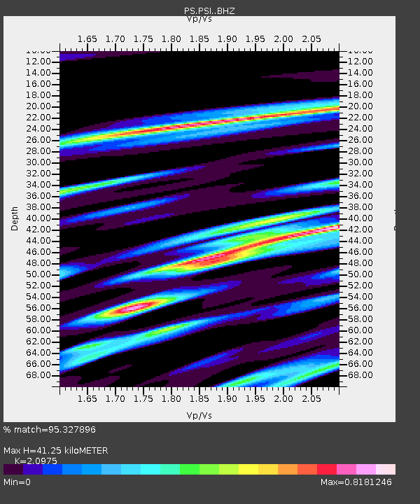
| Estimated Moho Depth: |
41.25 km |
| Estimated Crust Vp/Vs: |
2.10 |
| Assumed Crust Vp: |
6.468 km/s |
| Estimated Crust Vs: |
3.084 km/s |
| Estimated Crust Poisson's Ratio: |
0.35 |
|
| Radial Match: |
95.327896 % |
| Radial Bump: |
393 |
| Transverse Match: |
92.02016 % |
| Transverse Bump: |
400 |
| SOD ConfigId: |
13570011 |
| Insert Time: |
2019-04-28 23:19:51.720 +0000 |
| GWidth: |
2.5 |
| Max Bumps: |
400 |
| Tol: |
0.001 |
|
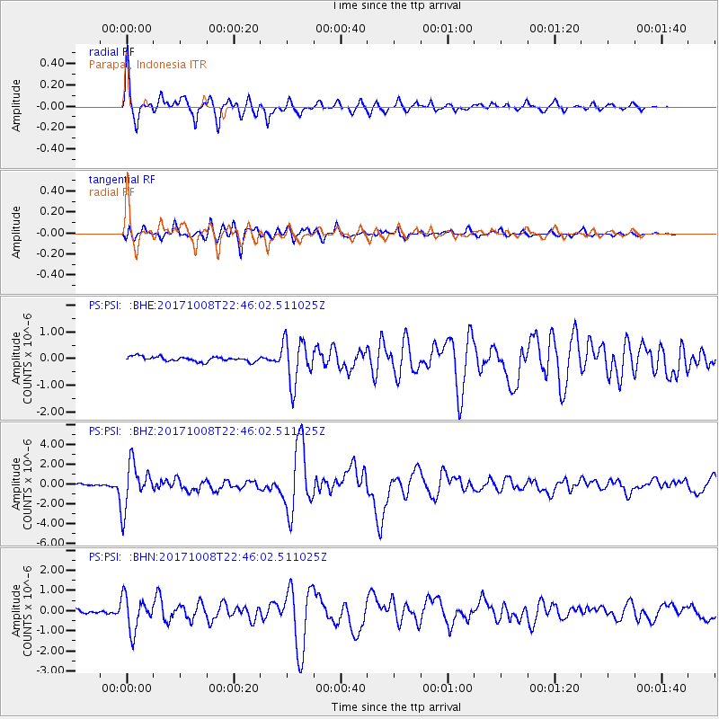
Signal To Noise
| Channel | StoN | STA | LTA |
| PS:PSI: :BHZ:20171008T22:46:02.511025Z | 26.50006 | 2.2480192E-6 | 8.4830724E-8 |
| PS:PSI: :BHN:20171008T22:46:02.511025Z | 9.581539 | 8.4538493E-7 | 8.823059E-8 |
| PS:PSI: :BHE:20171008T22:46:02.511025Z | 9.136253 | 8.330173E-7 | 9.117712E-8 |
| Arrivals |
| Ps | 7.2 SECOND |
| PpPs | 19 SECOND |
| PsPs/PpSs | 26 SECOND |


