You are here: Home > Network List > TA - USArray Transportable Network (new EarthScope stations) Stations List
> Station G14A Jackson, MT, USA > Earthquake Result Viewer
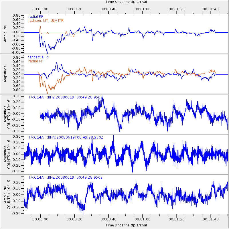
G14A Jackson, MT, USA - Earthquake Result Viewer
*The percent match for this event was below the threshold and hence no stack was calculated.
| Earthquake location: |
New Britain Region, P.N.G. |
| Earthquake latitude/longitude: |
-4.9/151.8 |
| Earthquake time(UTC): |
2008/06/19 (171) 00:36:45 GMT |
| Earthquake Depth: |
143 km |
| Earthquake Magnitude: |
5.5 MW, 5.2 MB, 5.4 MW |
| Earthquake Catalog/Contributor: |
WHDF/NEIC |
|
| Network: |
TA USArray Transportable Network (new EarthScope stations) |
| Station: |
G14A Jackson, MT, USA |
| Lat/Lon: |
45.24 N/113.46 W |
| Elevation: |
2140 m |
|
| Distance: |
96.8 deg |
| Az: |
45.159 deg |
| Baz: |
269.913 deg |
| Ray Param: |
$rayparam |
*The percent match for this event was below the threshold and hence was not used in the summary stack. |
|
| Radial Match: |
66.408394 % |
| Radial Bump: |
400 |
| Transverse Match: |
35.715343 % |
| Transverse Bump: |
400 |
| SOD ConfigId: |
2504 |
| Insert Time: |
2010-03-06 05:09:43.408 +0000 |
| GWidth: |
2.5 |
| Max Bumps: |
400 |
| Tol: |
0.001 |
|
Signal To Noise
| Channel | StoN | STA | LTA |
| TA:G14A: :BHN:20080619T00:49:28.950Z | 0.88469446 | 6.930982E-8 | 7.8343234E-8 |
| TA:G14A: :BHE:20080619T00:49:28.950Z | 1.2896297 | 1.0934256E-7 | 8.4786016E-8 |
| TA:G14A: :BHZ:20080619T00:49:28.950Z | 1.8304904 | 1.16168685E-7 | 6.346315E-8 |
| Arrivals |
| Ps | |
| PpPs | |
| PsPs/PpSs | |


