You are here: Home > Network List > TA - USArray Transportable Network (new EarthScope stations) Stations List
> Station G14A Jackson, MT, USA > Earthquake Result Viewer
G14A Jackson, MT, USA - Earthquake Result Viewer
*The percent match for this event was below the threshold and hence no stack was calculated.
| Earthquake location: |
Easter Island Region |
| Earthquake latitude/longitude: |
-28.5/-112.8 |
| Earthquake time(UTC): |
2008/08/19 (232) 10:58:00 GMT |
| Earthquake Depth: |
9.0 km |
| Earthquake Magnitude: |
5.5 MB, 5.3 MS, 5.7 MW, 5.7 MW |
| Earthquake Catalog/Contributor: |
WHDF/NEIC |
|
| Network: |
TA USArray Transportable Network (new EarthScope stations) |
| Station: |
G14A Jackson, MT, USA |
| Lat/Lon: |
45.24 N/113.46 W |
| Elevation: |
2140 m |
|
| Distance: |
73.4 deg |
| Az: |
359.544 deg |
| Baz: |
179.432 deg |
| Ray Param: |
$rayparam |
*The percent match for this event was below the threshold and hence was not used in the summary stack. |
|
| Radial Match: |
73.963135 % |
| Radial Bump: |
400 |
| Transverse Match: |
59.580368 % |
| Transverse Bump: |
398 |
| SOD ConfigId: |
2504 |
| Insert Time: |
2010-03-06 05:09:50.648 +0000 |
| GWidth: |
2.5 |
| Max Bumps: |
400 |
| Tol: |
0.001 |
|
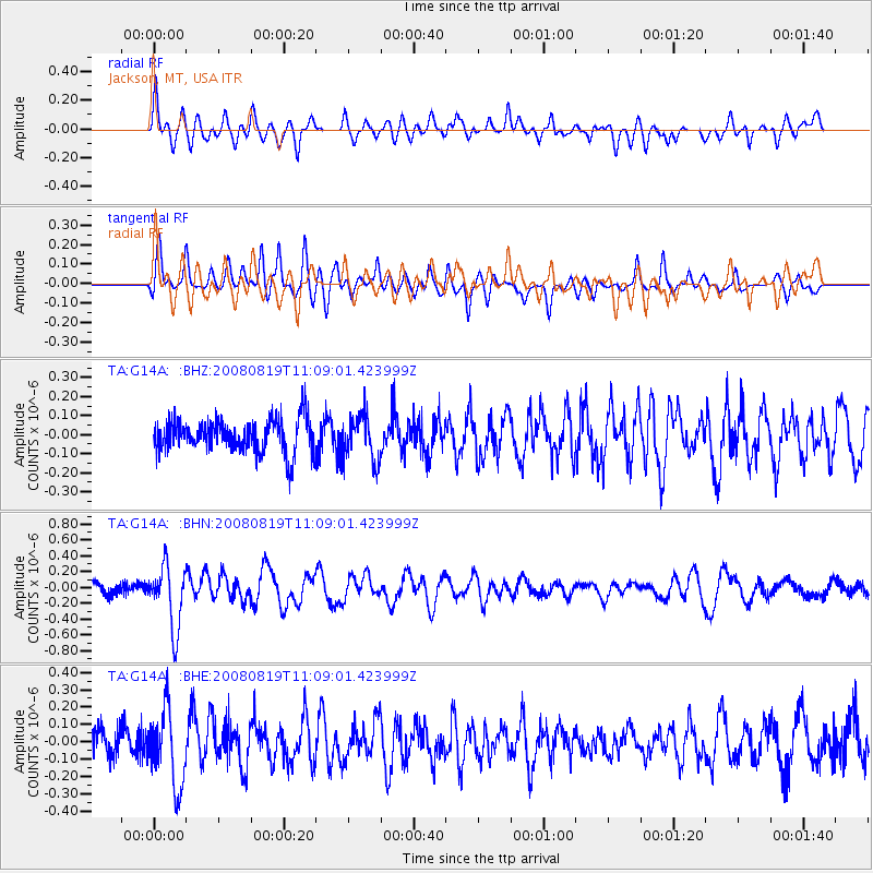
Signal To Noise
| Channel | StoN | STA | LTA |
| TA:G14A: :BHN:20080819T11:09:01.423999Z | 6.0826893 | 3.905897E-7 | 6.4213324E-8 |
| TA:G14A: :BHE:20080819T11:09:01.423999Z | 2.5454059 | 2.1842042E-7 | 8.580967E-8 |
| TA:G14A: :BHZ:20080819T11:09:01.423999Z | 1.3694664 | 1.2042578E-7 | 8.793627E-8 |
| Arrivals |
| Ps | |
| PpPs | |
| PsPs/PpSs | |


