You are here: Home > Network List > TA - USArray Transportable Network (new EarthScope stations) Stations List
> Station ABTX Abilene, Hawley, TX, USA > Earthquake Result Viewer
ABTX Abilene, Hawley, TX, USA - Earthquake Result Viewer
| Earthquake location: |
Rat Islands, Aleutian Islands |
| Earthquake latitude/longitude: |
52.4/176.8 |
| Earthquake time(UTC): |
2017/10/08 (281) 22:34:33 GMT |
| Earthquake Depth: |
112 km |
| Earthquake Magnitude: |
6.6 mww |
| Earthquake Catalog/Contributor: |
NEIC PDE/us |
|
| Network: |
TA USArray Transportable Network (new EarthScope stations) |
| Station: |
ABTX Abilene, Hawley, TX, USA |
| Lat/Lon: |
32.62 N/99.64 W |
| Elevation: |
502 m |
|
| Distance: |
61.2 deg |
| Az: |
73.185 deg |
| Baz: |
316.032 deg |
| Ray Param: |
0.06073812 |
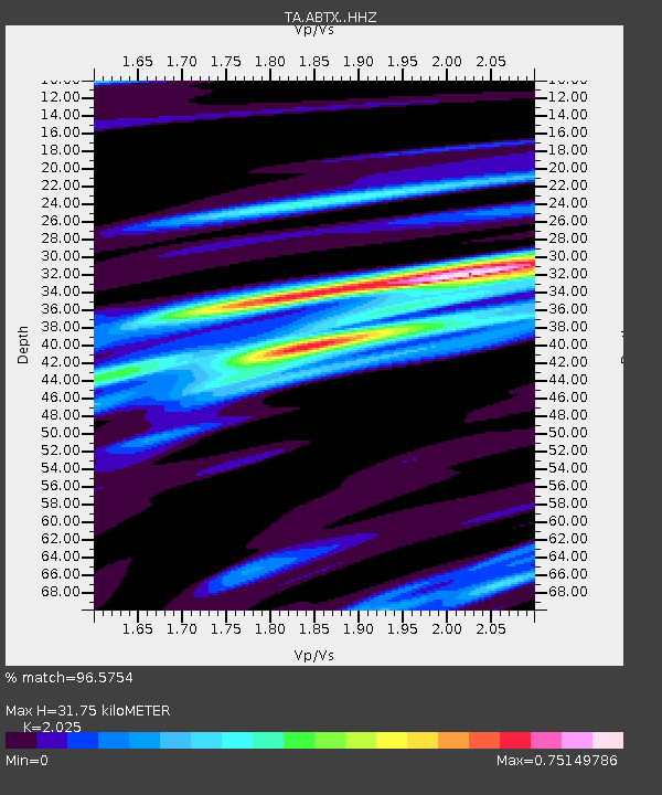
| Estimated Moho Depth: |
31.75 km |
| Estimated Crust Vp/Vs: |
2.03 |
| Assumed Crust Vp: |
6.426 km/s |
| Estimated Crust Vs: |
3.173 km/s |
| Estimated Crust Poisson's Ratio: |
0.34 |
|
| Radial Match: |
96.5754 % |
| Radial Bump: |
260 |
| Transverse Match: |
77.38377 % |
| Transverse Bump: |
400 |
| SOD ConfigId: |
13570011 |
| Insert Time: |
2019-04-28 23:20:50.498 +0000 |
| GWidth: |
2.5 |
| Max Bumps: |
400 |
| Tol: |
0.001 |
|

Signal To Noise
| Channel | StoN | STA | LTA |
| TA:ABTX: :HHZ:20171008T22:44:05.960Z | 43.223755 | 5.6603544E-6 | 1.3095472E-7 |
| TA:ABTX: :HHN:20171008T22:44:05.960Z | 15.2516365 | 1.822042E-6 | 1.1946534E-7 |
| TA:ABTX: :HHE:20171008T22:44:05.960Z | 13.462198 | 1.9360436E-6 | 1.4381334E-7 |
| Arrivals |
| Ps | 5.3 SECOND |
| PpPs | 14 SECOND |
| PsPs/PpSs | 20 SECOND |


