You are here: Home > Network List > TA - USArray Transportable Network (new EarthScope stations) Stations List
> Station O48B Farmland, IN, USA > Earthquake Result Viewer
O48B Farmland, IN, USA - Earthquake Result Viewer
| Earthquake location: |
Rat Islands, Aleutian Islands |
| Earthquake latitude/longitude: |
52.4/176.8 |
| Earthquake time(UTC): |
2017/10/08 (281) 22:34:33 GMT |
| Earthquake Depth: |
112 km |
| Earthquake Magnitude: |
6.6 mww |
| Earthquake Catalog/Contributor: |
NEIC PDE/us |
|
| Network: |
TA USArray Transportable Network (new EarthScope stations) |
| Station: |
O48B Farmland, IN, USA |
| Lat/Lon: |
40.26 N/85.16 W |
| Elevation: |
300 m |
|
| Distance: |
63.7 deg |
| Az: |
57.725 deg |
| Baz: |
317.454 deg |
| Ray Param: |
0.059114303 |
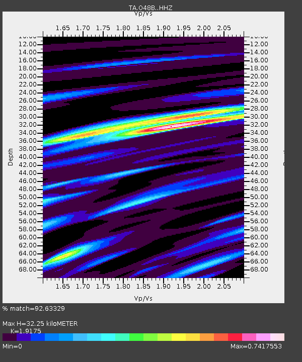
| Estimated Moho Depth: |
32.25 km |
| Estimated Crust Vp/Vs: |
1.92 |
| Assumed Crust Vp: |
6.498 km/s |
| Estimated Crust Vs: |
3.389 km/s |
| Estimated Crust Poisson's Ratio: |
0.31 |
|
| Radial Match: |
92.63329 % |
| Radial Bump: |
379 |
| Transverse Match: |
63.93022 % |
| Transverse Bump: |
400 |
| SOD ConfigId: |
13570011 |
| Insert Time: |
2019-04-28 23:21:02.606 +0000 |
| GWidth: |
2.5 |
| Max Bumps: |
400 |
| Tol: |
0.001 |
|

Signal To Noise
| Channel | StoN | STA | LTA |
| TA:O48B: :HHZ:20171008T22:44:22.600015Z | 21.192825 | 3.2221221E-6 | 1.5203834E-7 |
| TA:O48B: :HHN:20171008T22:44:22.600015Z | 10.141356 | 1.3329262E-6 | 1.314347E-7 |
| TA:O48B: :HHE:20171008T22:44:22.600015Z | 11.343839 | 1.1591328E-6 | 1.0218171E-7 |
| Arrivals |
| Ps | 4.7 SECOND |
| PpPs | 14 SECOND |
| PsPs/PpSs | 19 SECOND |


