You are here: Home > Network List > TA - USArray Transportable Network (new EarthScope stations) Stations List
> Station G13A Cobalt, ID, USA > Earthquake Result Viewer
G13A Cobalt, ID, USA - Earthquake Result Viewer
| Earthquake location: |
Loyalty Islands |
| Earthquake latitude/longitude: |
-20.1/168.9 |
| Earthquake time(UTC): |
2008/04/09 (100) 12:46:12 GMT |
| Earthquake Depth: |
33 km |
| Earthquake Magnitude: |
6.3 MB, 7.3 MS, 7.3 MW, 7.3 MW |
| Earthquake Catalog/Contributor: |
WHDF/NEIC |
|
| Network: |
TA USArray Transportable Network (new EarthScope stations) |
| Station: |
G13A Cobalt, ID, USA |
| Lat/Lon: |
45.09 N/114.23 W |
| Elevation: |
1538 m |
|
| Distance: |
95.1 deg |
| Az: |
43.837 deg |
| Baz: |
246.802 deg |
| Ray Param: |
0.040846538 |
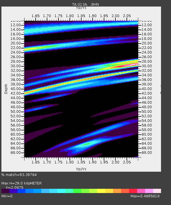
| Estimated Moho Depth: |
29.0 km |
| Estimated Crust Vp/Vs: |
2.09 |
| Assumed Crust Vp: |
6.577 km/s |
| Estimated Crust Vs: |
3.151 km/s |
| Estimated Crust Poisson's Ratio: |
0.35 |
|
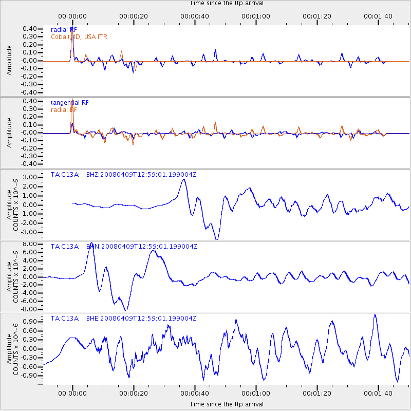
| Radial Match: |
93.39764 % |
| Radial Bump: |
270 |
| Transverse Match: |
81.10021 % |
| Transverse Bump: |
289 |
| SOD ConfigId: |
2504 |
| Insert Time: |
2010-03-06 05:10:06.880 +0000 |
| GWidth: |
2.5 |
| Max Bumps: |
400 |
| Tol: |
0.001 |
|
Signal To Noise
| Channel | StoN | STA | LTA |
| TA:G13A: :BHN:20080409T12:59:01.199004Z | 3.9483628 | 1.4207183E-6 | 3.5982467E-7 |
| TA:G13A: :BHE:20080409T12:59:01.199004Z | 1.0006734 | 3.2743515E-7 | 3.2721476E-7 |
| TA:G13A: :BHZ:20080409T12:59:01.199004Z | 3.575102 | 6.425972E-7 | 1.7974233E-7 |
| Arrivals |
| Ps | 4.9 SECOND |
| PpPs | 13 SECOND |
| PsPs/PpSs | 18 SECOND |


