You are here: Home > Network List > GS - US Geological Survey Networks Stations List
> Station DEC06 Boomer, Decatur, IL, USA > Earthquake Result Viewer
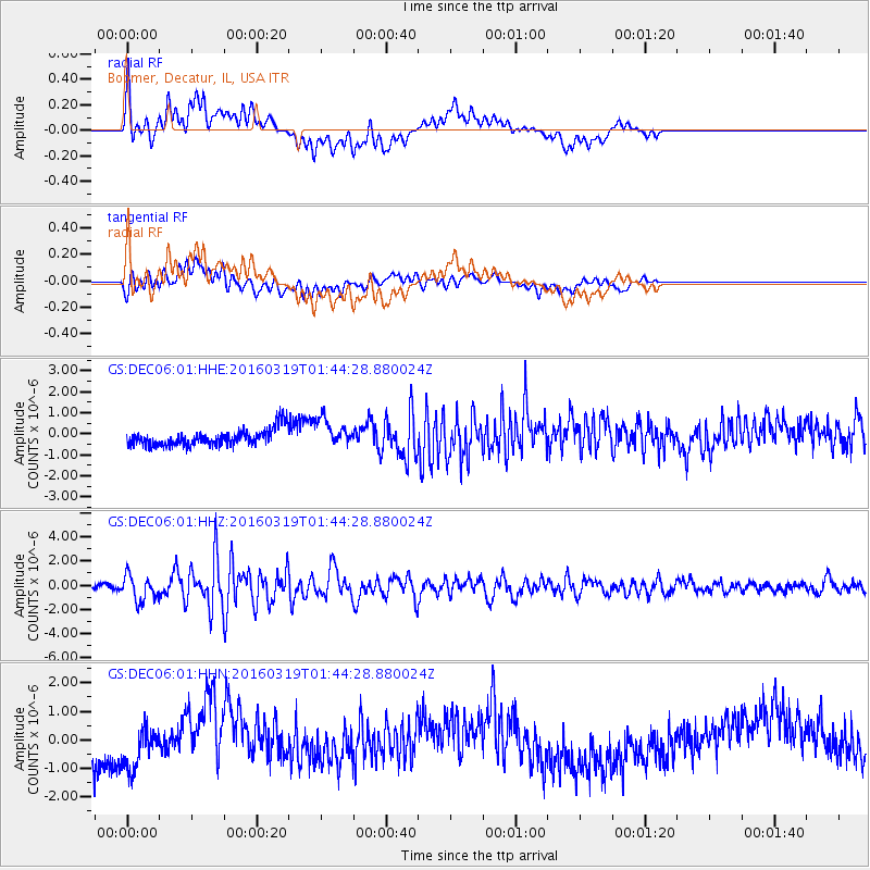
DEC06 Boomer, Decatur, IL, USA - Earthquake Result Viewer
*The percent match for this event was below the threshold and hence no stack was calculated.
| Earthquake location: |
Andreanof Islands, Aleutian Is. |
| Earthquake latitude/longitude: |
51.5/-174.2 |
| Earthquake time(UTC): |
2016/03/19 (079) 01:35:12 GMT |
| Earthquake Depth: |
17 km |
| Earthquake Magnitude: |
6.0 MWW, 5.5 ML, 5.8 MWB |
| Earthquake Catalog/Contributor: |
NEIC PDE/NEIC COMCAT |
|
| Network: |
GS US Geological Survey Networks |
| Station: |
DEC06 Boomer, Decatur, IL, USA |
| Lat/Lon: |
39.90 N/88.95 W |
| Elevation: |
215 m |
|
| Distance: |
57.4 deg |
| Az: |
65.47 deg |
| Baz: |
312.356 deg |
| Ray Param: |
$rayparam |
*The percent match for this event was below the threshold and hence was not used in the summary stack. |
|
| Radial Match: |
32.924362 % |
| Radial Bump: |
400 |
| Transverse Match: |
45.809273 % |
| Transverse Bump: |
400 |
| SOD ConfigId: |
1464191 |
| Insert Time: |
2016-04-02 02:06:25.838 +0000 |
| GWidth: |
2.5 |
| Max Bumps: |
400 |
| Tol: |
0.001 |
|
Signal To Noise
| Channel | StoN | STA | LTA |
| GS:DEC06:01:HHZ:20160319T01:44:28.880024Z | 6.242255 | 1.040197E-6 | 1.6663802E-7 |
| GS:DEC06:01:HHN:20160319T01:44:28.880024Z | 1.6402183 | 7.477427E-7 | 4.5587998E-7 |
| GS:DEC06:01:HHE:20160319T01:44:28.880024Z | 1.6725365 | 6.47419E-7 | 3.870881E-7 |
| Arrivals |
| Ps | |
| PpPs | |
| PsPs/PpSs | |


