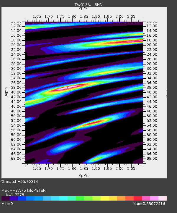
G13A Cobalt, ID, USA - Earthquake Result Viewer
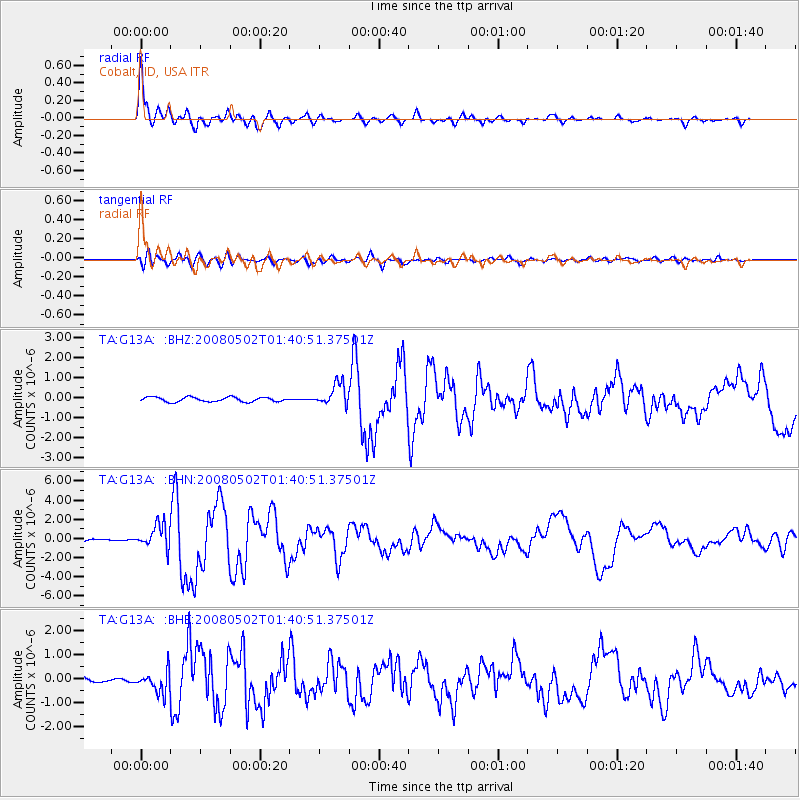
Earthquake location: Andreanof Islands, Aleutian Is.
Earthquake latitude/longitude: 51.9/-177.5
Earthquake time(UTC): 2008/05/02 (123) 01:33:37 GMT
Earthquake Depth: 14 km
Earthquake Magnitude: 6.3 MB, 6.8 MS, 6.6 MW, 6.6 MW
Earthquake Catalog/Contributor: WHDF/NEIC
Network: TA USArray Transportable Network (new EarthScope stations)
Station: G13A Cobalt, ID, USA
Lat/Lon: 45.09 N/114.23 W
Elevation: 1538 m
Distance: 41.3 deg
Az: 73.455 deg
Baz: 302.946 deg
Ray Param: 0.073862985
Estimated Moho Depth: 37.75 km
Estimated Crust Vp/Vs: 1.78
Assumed Crust Vp: 6.577 km/s
Estimated Crust Vs: 3.7 km/s
Estimated Crust Poisson's Ratio: 0.27
Radial Match: 95.70314 %
Radial Bump: 400
Transverse Match: 81.030075 %
Transverse Bump: 400
SOD ConfigId: 2504
Insert Time: 2010-03-06 05:10:12.873 +0000
GWidth: 2.5
Max Bumps: 400
Tol: 0.001

Signal To Noise

ChannelStoNSTALTA
TA:G13A: :BHN:20080502T01:40:51.37501Z10.6699911.226076E-61.1490882E-7
TA:G13A: :BHE:20080502T01:40:51.37501Z4.2495064.5110082E-71.06153706E-7
TA:G13A: :BHZ:20080502T01:40:51.37501Z4.90830235.512887E-71.1231758E-7
Arrivals
Ps4.8 SECOND
PpPs15 SECOND
PsPs/PpSs20 SECOND