You are here: Home > Network List > TA - USArray Transportable Network (new EarthScope stations) Stations List
> Station G13A Cobalt, ID, USA > Earthquake Result Viewer
G13A Cobalt, ID, USA - Earthquake Result Viewer
| Earthquake location: |
South Of Mariana Islands |
| Earthquake latitude/longitude: |
12.5/143.2 |
| Earthquake time(UTC): |
2008/05/09 (130) 21:51:29 GMT |
| Earthquake Depth: |
76 km |
| Earthquake Magnitude: |
6.1 MB, 6.7 MW, 6.7 MW |
| Earthquake Catalog/Contributor: |
WHDF/NEIC |
|
| Network: |
TA USArray Transportable Network (new EarthScope stations) |
| Station: |
G13A Cobalt, ID, USA |
| Lat/Lon: |
45.09 N/114.23 W |
| Elevation: |
1538 m |
|
| Distance: |
89.9 deg |
| Az: |
43.734 deg |
| Baz: |
287.622 deg |
| Ray Param: |
0.041695915 |
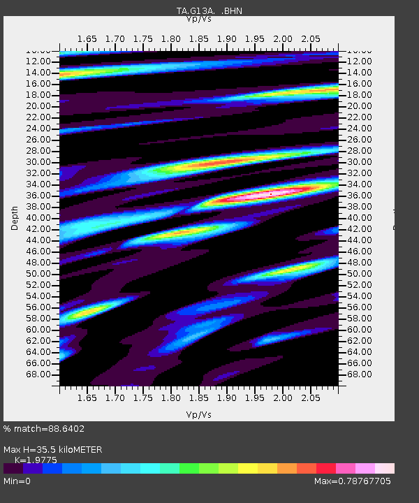
| Estimated Moho Depth: |
35.5 km |
| Estimated Crust Vp/Vs: |
1.98 |
| Assumed Crust Vp: |
6.577 km/s |
| Estimated Crust Vs: |
3.326 km/s |
| Estimated Crust Poisson's Ratio: |
0.33 |
|
| Radial Match: |
88.6402 % |
| Radial Bump: |
400 |
| Transverse Match: |
77.171715 % |
| Transverse Bump: |
400 |
| SOD ConfigId: |
2504 |
| Insert Time: |
2010-03-06 05:10:16.694 +0000 |
| GWidth: |
2.5 |
| Max Bumps: |
400 |
| Tol: |
0.001 |
|

Signal To Noise
| Channel | StoN | STA | LTA |
| TA:G13A: :BHN:20080509T22:03:49.25002Z | 10.675369 | 6.003987E-7 | 5.6241497E-8 |
| TA:G13A: :BHE:20080509T22:03:49.25002Z | 2.8264222 | 1.4172447E-7 | 5.014271E-8 |
| TA:G13A: :BHZ:20080509T22:03:49.25002Z | 2.4958873 | 1.6319845E-7 | 6.538695E-8 |
| Arrivals |
| Ps | 5.4 SECOND |
| PpPs | 16 SECOND |
| PsPs/PpSs | 21 SECOND |


