You are here: Home > Network List > UW - Pacific Northwest Regional Seismic Network Stations List
> Station MRBL Marblemount, WA, USA > Earthquake Result Viewer
MRBL Marblemount, WA, USA - Earthquake Result Viewer
*The percent match for this event was below the threshold and hence no stack was calculated.
| Earthquake location: |
Rat Islands, Aleutian Islands |
| Earthquake latitude/longitude: |
52.4/176.8 |
| Earthquake time(UTC): |
2017/10/08 (281) 22:34:33 GMT |
| Earthquake Depth: |
112 km |
| Earthquake Magnitude: |
6.6 mww |
| Earthquake Catalog/Contributor: |
NEIC PDE/us |
|
| Network: |
UW Pacific Northwest Regional Seismic Network |
| Station: |
MRBL Marblemount, WA, USA |
| Lat/Lon: |
48.52 N/121.48 W |
| Elevation: |
75 m |
|
| Distance: |
38.4 deg |
| Az: |
70.446 deg |
| Baz: |
299.839 deg |
| Ray Param: |
$rayparam |
*The percent match for this event was below the threshold and hence was not used in the summary stack. |
|
| Radial Match: |
69.75843 % |
| Radial Bump: |
242 |
| Transverse Match: |
73.91294 % |
| Transverse Bump: |
400 |
| SOD ConfigId: |
13570011 |
| Insert Time: |
2019-04-28 23:22:16.092 +0000 |
| GWidth: |
2.5 |
| Max Bumps: |
400 |
| Tol: |
0.001 |
|
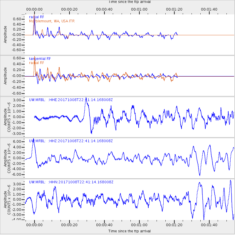
Signal To Noise
| Channel | StoN | STA | LTA |
| UW:MRBL: :HHZ:20171008T22:41:14.168008Z | 8.034771 | 3.5272483E-6 | 4.38998E-7 |
| UW:MRBL: :HHN:20171008T22:41:14.168008Z | 3.7555432 | 1.5170056E-6 | 4.0393772E-7 |
| UW:MRBL: :HHE:20171008T22:41:14.168008Z | 8.931686 | 2.1477986E-6 | 2.4046955E-7 |
| Arrivals |
| Ps | |
| PpPs | |
| PsPs/PpSs | |


