You are here: Home > Network List > X812 - Deep Structure of Three Continental Sutures in Eastern North America Stations List
> Station COSY Clark's Harbour, Nova Scotia > Earthquake Result Viewer
COSY Clark's Harbour, Nova Scotia - Earthquake Result Viewer
| Earthquake location: |
Rat Islands, Aleutian Islands |
| Earthquake latitude/longitude: |
52.4/176.8 |
| Earthquake time(UTC): |
2017/10/08 (281) 22:34:33 GMT |
| Earthquake Depth: |
112 km |
| Earthquake Magnitude: |
6.6 mww |
| Earthquake Catalog/Contributor: |
NEIC PDE/us |
|
| Network: |
X8 Deep Structure of Three Continental Sutures in Eastern North America |
| Station: |
COSY Clark's Harbour, Nova Scotia |
| Lat/Lon: |
43.44 N/65.63 W |
| Elevation: |
0.0 m |
|
| Distance: |
70.4 deg |
| Az: |
43.271 deg |
| Baz: |
324.835 deg |
| Ray Param: |
0.05472571 |
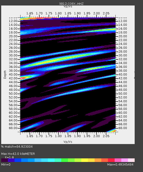
| Estimated Moho Depth: |
42.0 km |
| Estimated Crust Vp/Vs: |
1.60 |
| Assumed Crust Vp: |
6.134 km/s |
| Estimated Crust Vs: |
3.834 km/s |
| Estimated Crust Poisson's Ratio: |
0.18 |
|
| Radial Match: |
84.923004 % |
| Radial Bump: |
400 |
| Transverse Match: |
75.82669 % |
| Transverse Bump: |
400 |
| SOD ConfigId: |
13570011 |
| Insert Time: |
2019-04-28 23:23:11.365 +0000 |
| GWidth: |
2.5 |
| Max Bumps: |
400 |
| Tol: |
0.001 |
|

Signal To Noise
| Channel | StoN | STA | LTA |
| X8:COSY: :HHZ:20171008T22:45:05.040017Z | 10.946644 | 3.2508412E-6 | 2.969715E-7 |
| X8:COSY: :HHN:20171008T22:45:05.040017Z | 6.707864 | 1.2393658E-6 | 1.8476312E-7 |
| X8:COSY: :HHE:20171008T22:45:05.040017Z | 2.314252 | 5.5085707E-7 | 2.3802812E-7 |
| Arrivals |
| Ps | 4.3 SECOND |
| PpPs | 17 SECOND |
| PsPs/PpSs | 21 SECOND |


