You are here: Home > Network List > UW - Pacific Northwest Regional Seismic Network Stations List
> Station WA2 Wahluke Slope previous ISC code: WAH2 > Earthquake Result Viewer
WA2 Wahluke Slope previous ISC code: WAH2 - Earthquake Result Viewer
| Earthquake location: |
Rat Islands, Aleutian Islands |
| Earthquake latitude/longitude: |
52.4/176.8 |
| Earthquake time(UTC): |
2017/10/08 (281) 22:34:33 GMT |
| Earthquake Depth: |
112 km |
| Earthquake Magnitude: |
6.6 mww |
| Earthquake Catalog/Contributor: |
NEIC PDE/us |
|
| Network: |
UW Pacific Northwest Regional Seismic Network |
| Station: |
WA2 Wahluke Slope previous ISC code: WAH2 |
| Lat/Lon: |
46.76 N/119.57 W |
| Elevation: |
244 m |
|
| Distance: |
40.4 deg |
| Az: |
71.772 deg |
| Baz: |
302.276 deg |
| Ray Param: |
0.074018195 |
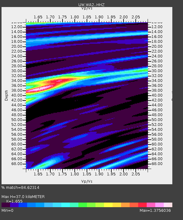
| Estimated Moho Depth: |
37.0 km |
| Estimated Crust Vp/Vs: |
1.65 |
| Assumed Crust Vp: |
6.419 km/s |
| Estimated Crust Vs: |
3.879 km/s |
| Estimated Crust Poisson's Ratio: |
0.21 |
|
| Radial Match: |
84.62314 % |
| Radial Bump: |
400 |
| Transverse Match: |
59.823708 % |
| Transverse Bump: |
400 |
| SOD ConfigId: |
13570011 |
| Insert Time: |
2019-04-28 23:23:46.336 +0000 |
| GWidth: |
2.5 |
| Max Bumps: |
400 |
| Tol: |
0.001 |
|

Signal To Noise
| Channel | StoN | STA | LTA |
| UW:WA2: :HHZ:20171008T22:41:30.910012Z | 15.364009 | 4.4164776E-6 | 2.8745606E-7 |
| UW:WA2: :HHN:20171008T22:41:30.910012Z | 5.36252 | 1.4269659E-6 | 2.6609987E-7 |
| UW:WA2: :HHE:20171008T22:41:30.910012Z | 8.602702 | 1.6882049E-6 | 1.9624123E-7 |
| Arrivals |
| Ps | 4.1 SECOND |
| PpPs | 14 SECOND |
| PsPs/PpSs | 18 SECOND |


