You are here: Home > Network List > YO16 - Yukon Observatory Stations List
> Station LIRD YGS, Liard River Highway Maintenance Camp, BC > Earthquake Result Viewer
LIRD YGS, Liard River Highway Maintenance Camp, BC - Earthquake Result Viewer
| Earthquake location: |
Rat Islands, Aleutian Islands |
| Earthquake latitude/longitude: |
52.4/176.8 |
| Earthquake time(UTC): |
2017/10/08 (281) 22:34:33 GMT |
| Earthquake Depth: |
112 km |
| Earthquake Magnitude: |
6.6 mww |
| Earthquake Catalog/Contributor: |
NEIC PDE/us |
|
| Network: |
YO Yukon Observatory |
| Station: |
LIRD YGS, Liard River Highway Maintenance Camp, BC |
| Lat/Lon: |
59.41 N/126.10 W |
| Elevation: |
439 m |
|
| Distance: |
31.8 deg |
| Az: |
54.506 deg |
| Baz: |
283.011 deg |
| Ray Param: |
0.078609385 |
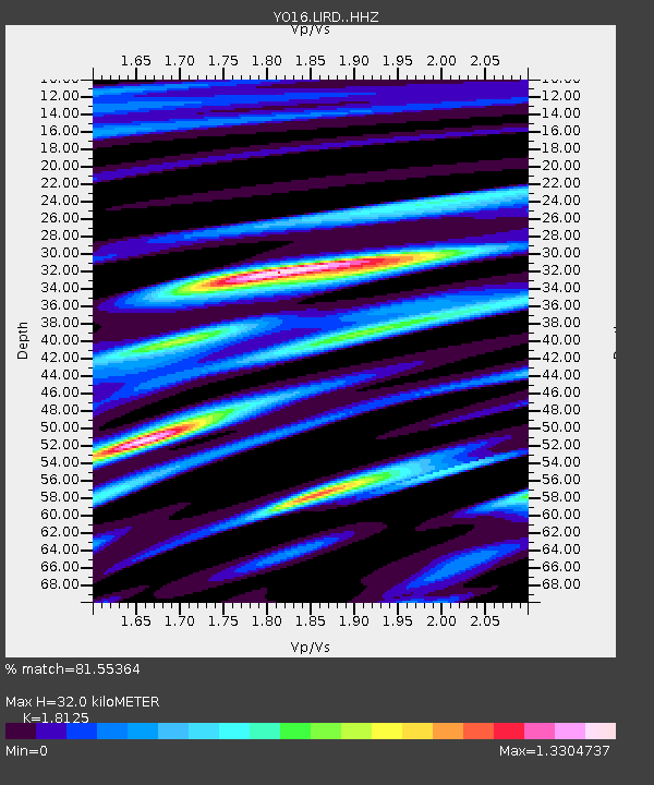
| Estimated Moho Depth: |
32.0 km |
| Estimated Crust Vp/Vs: |
1.81 |
| Assumed Crust Vp: |
6.419 km/s |
| Estimated Crust Vs: |
3.542 km/s |
| Estimated Crust Poisson's Ratio: |
0.28 |
|
| Radial Match: |
81.55364 % |
| Radial Bump: |
400 |
| Transverse Match: |
65.132416 % |
| Transverse Bump: |
400 |
| SOD ConfigId: |
13570011 |
| Insert Time: |
2019-04-28 23:23:47.029 +0000 |
| GWidth: |
2.5 |
| Max Bumps: |
400 |
| Tol: |
0.001 |
|

Signal To Noise
| Channel | StoN | STA | LTA |
| YO:LIRD: :HHZ:20171008T22:40:17.880013Z | 22.697699 | 7.3639662E-6 | 3.2443668E-7 |
| YO:LIRD: :HHN:20171008T22:40:17.880013Z | 9.53131 | 2.3629204E-6 | 2.479114E-7 |
| YO:LIRD: :HHE:20171008T22:40:17.880013Z | 19.190405 | 5.0374824E-6 | 2.6250004E-7 |
| Arrivals |
| Ps | 4.4 SECOND |
| PpPs | 13 SECOND |
| PsPs/PpSs | 17 SECOND |


