You are here: Home > Network List > TA - USArray Transportable Network (new EarthScope stations) Stations List
> Station G13A Cobalt, ID, USA > Earthquake Result Viewer
G13A Cobalt, ID, USA - Earthquake Result Viewer
| Earthquake location: |
Santa Cruz Islands |
| Earthquake latitude/longitude: |
-11.4/166.2 |
| Earthquake time(UTC): |
2008/08/12 (225) 05:25:57 GMT |
| Earthquake Depth: |
38 km |
| Earthquake Magnitude: |
5.9 MW, 5.4 MS, 5.2 MB, 5.8 MW |
| Earthquake Catalog/Contributor: |
WHDF/NEIC |
|
| Network: |
TA USArray Transportable Network (new EarthScope stations) |
| Station: |
G13A Cobalt, ID, USA |
| Lat/Lon: |
45.09 N/114.23 W |
| Elevation: |
1538 m |
|
| Distance: |
90.7 deg |
| Az: |
44.156 deg |
| Baz: |
254.622 deg |
| Ray Param: |
0.041646887 |
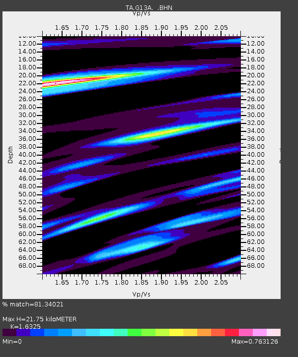
| Estimated Moho Depth: |
21.75 km |
| Estimated Crust Vp/Vs: |
1.63 |
| Assumed Crust Vp: |
6.577 km/s |
| Estimated Crust Vs: |
4.029 km/s |
| Estimated Crust Poisson's Ratio: |
0.20 |
|
| Radial Match: |
81.34021 % |
| Radial Bump: |
400 |
| Transverse Match: |
69.78063 % |
| Transverse Bump: |
350 |
| SOD ConfigId: |
2504 |
| Insert Time: |
2010-03-06 05:10:38.478 +0000 |
| GWidth: |
2.5 |
| Max Bumps: |
400 |
| Tol: |
0.001 |
|
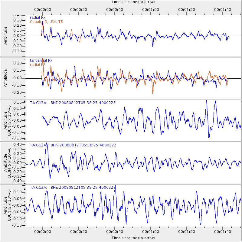
Signal To Noise
| Channel | StoN | STA | LTA |
| TA:G13A: :BHN:20080812T05:38:25.400022Z | 6.2691736 | 2.2703793E-7 | 3.621497E-8 |
| TA:G13A: :BHE:20080812T05:38:25.400022Z | 1.5814806 | 6.47034E-8 | 4.0913182E-8 |
| TA:G13A: :BHZ:20080812T05:38:25.400022Z | 1.4051818 | 4.947755E-8 | 3.5210782E-8 |
| Arrivals |
| Ps | 2.1 SECOND |
| PpPs | 8.5 SECOND |
| PsPs/PpSs | 11 SECOND |


