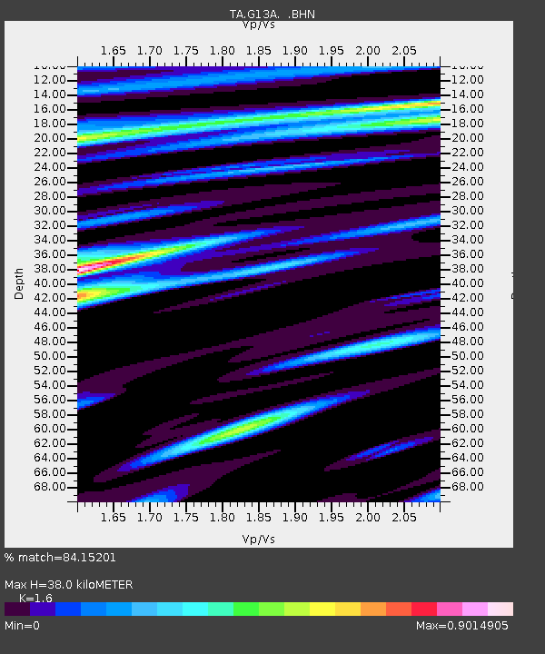
G13A Cobalt, ID, USA - Earthquake Result Viewer
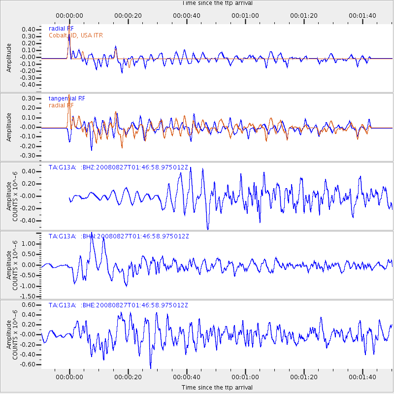
Earthquake location: Lake Baykal Region, Russia
Earthquake latitude/longitude: 51.6/104.2
Earthquake time(UTC): 2008/08/27 (240) 01:35:32 GMT
Earthquake Depth: 16 km
Earthquake Magnitude: 5.8 MB, 6.2 MS, 6.2 MW, 6.2 MW
Earthquake Catalog/Contributor: WHDF/NEIC
Network: TA USArray Transportable Network (new EarthScope stations)
Station: G13A Cobalt, ID, USA
Lat/Lon: 45.09 N/114.23 W
Elevation: 1538 m
Distance: 78.1 deg
Az: 26.711 deg
Baz: 336.688 deg
Ray Param: 0.049836073
Estimated Moho Depth: 38.0 km
Estimated Crust Vp/Vs: 1.60
Assumed Crust Vp: 6.577 km/s
Estimated Crust Vs: 4.111 km/s
Estimated Crust Poisson's Ratio: 0.18
Radial Match: 84.15201 %
Radial Bump: 400
Transverse Match: 71.8434 %
Transverse Bump: 400
SOD ConfigId: 2504
Insert Time: 2010-03-06 05:10:44.451 +0000
GWidth: 2.5
Max Bumps: 400
Tol: 0.001

Signal To Noise

ChannelStoNSTALTA
TA:G13A: :BHN:20080827T01:46:58.975012Z5.22363044.209047E-78.057705E-8
TA:G13A: :BHE:20080827T01:46:58.975012Z1.81592731.2867746E-77.0860466E-8
TA:G13A: :BHZ:20080827T01:46:58.975012Z1.91808011.1865147E-76.1859495E-8
Arrivals
Ps3.6 SECOND
PpPs15 SECOND
PsPs/PpSs18 SECOND