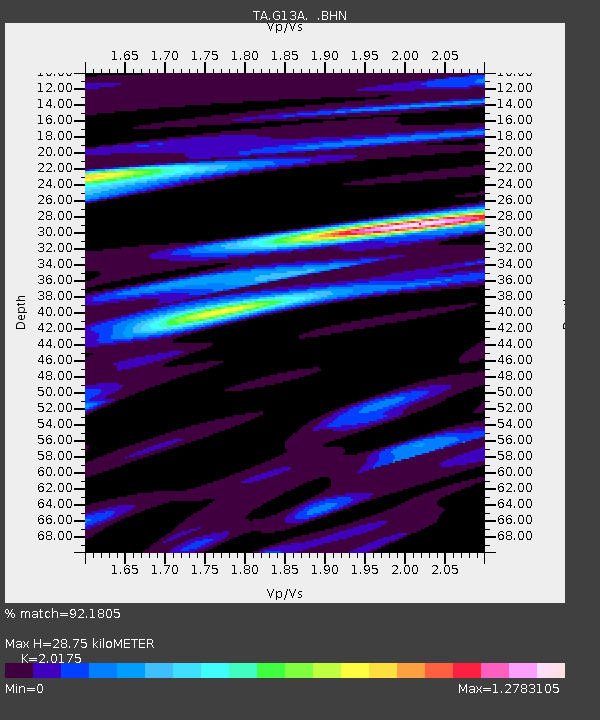
G13A Cobalt, ID, USA - Earthquake Result Viewer
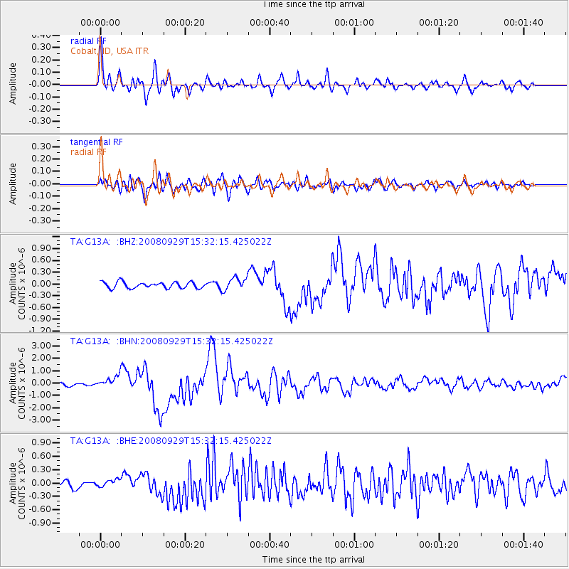
Earthquake location: Kermadec Islands, New Zealand
Earthquake latitude/longitude: -29.8/-177.7
Earthquake time(UTC): 2008/09/29 (273) 15:19:31 GMT
Earthquake Depth: 36 km
Earthquake Magnitude: 6.5 MB, 6.7 MS, 7.0 MW, 7.0 MW
Earthquake Catalog/Contributor: WHDF/NEIC
Network: TA USArray Transportable Network (new EarthScope stations)
Station: G13A Cobalt, ID, USA
Lat/Lon: 45.09 N/114.23 W
Elevation: 1538 m
Distance: 94.2 deg
Az: 39.445 deg
Baz: 231.258 deg
Ray Param: 0.04108434
Estimated Moho Depth: 28.75 km
Estimated Crust Vp/Vs: 2.02
Assumed Crust Vp: 6.577 km/s
Estimated Crust Vs: 3.26 km/s
Estimated Crust Poisson's Ratio: 0.34
Radial Match: 92.1805 %
Radial Bump: 400
Transverse Match: 85.89373 %
Transverse Bump: 400
SOD ConfigId: 2560
Insert Time: 2010-03-06 05:10:57.824 +0000
GWidth: 2.5
Max Bumps: 400
Tol: 0.001

Signal To Noise

ChannelStoNSTALTA
TA:G13A: :BHN:20080929T15:32:15.425022Z5.7452984.997623E-78.698631E-8
TA:G13A: :BHE:20080929T15:32:15.425022Z1.4011258.8118284E-86.28911E-8
TA:G13A: :BHZ:20080929T15:32:15.425022Z2.06985951.6342366E-77.895399E-8
Arrivals
Ps4.5 SECOND
PpPs13 SECOND
PsPs/PpSs17 SECOND