You are here: Home > Network List > TA - USArray Transportable Network (new EarthScope stations) Stations List
> Station G13A Cobalt, ID, USA > Earthquake Result Viewer
G13A Cobalt, ID, USA - Earthquake Result Viewer
| Earthquake location: |
Near Coast Of Northern Chile |
| Earthquake latitude/longitude: |
-20.2/-70.0 |
| Earthquake time(UTC): |
2008/02/04 (035) 17:01:30 GMT |
| Earthquake Depth: |
44 km |
| Earthquake Magnitude: |
6.0 MB, 6.2 MS, 6.3 MW, 6.3 MW |
| Earthquake Catalog/Contributor: |
WHDF/NEIC |
|
| Network: |
TA USArray Transportable Network (new EarthScope stations) |
| Station: |
G13A Cobalt, ID, USA |
| Lat/Lon: |
45.09 N/114.23 W |
| Elevation: |
1538 m |
|
| Distance: |
76.4 deg |
| Az: |
329.467 deg |
| Baz: |
137.639 deg |
| Ray Param: |
0.05094716 |
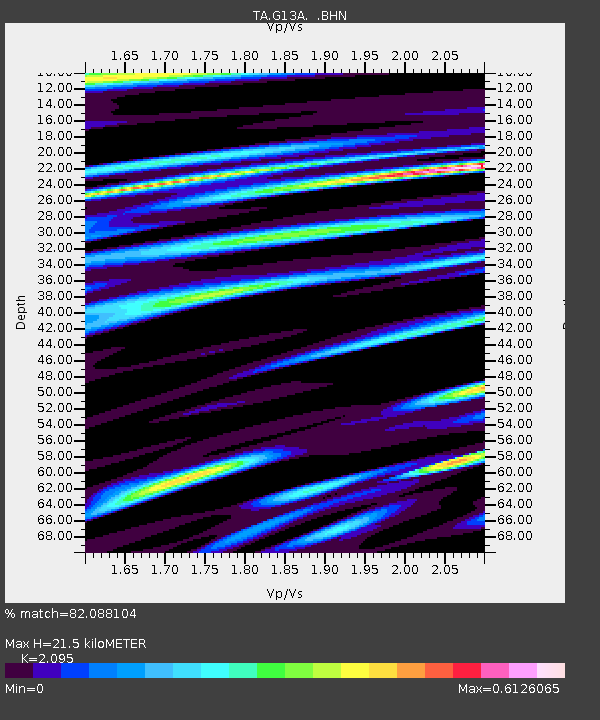
| Estimated Moho Depth: |
21.5 km |
| Estimated Crust Vp/Vs: |
2.10 |
| Assumed Crust Vp: |
6.577 km/s |
| Estimated Crust Vs: |
3.139 km/s |
| Estimated Crust Poisson's Ratio: |
0.35 |
|
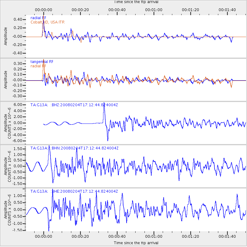
| Radial Match: |
82.088104 % |
| Radial Bump: |
400 |
| Transverse Match: |
83.29089 % |
| Transverse Bump: |
400 |
| SOD ConfigId: |
2564 |
| Insert Time: |
2010-03-06 05:11:03.837 +0000 |
| GWidth: |
2.5 |
| Max Bumps: |
400 |
| Tol: |
0.001 |
|
Signal To Noise
| Channel | StoN | STA | LTA |
| TA:G13A: :BHN:20080204T17:12:44.824004Z | 3.132277 | 7.167852E-7 | 2.2883839E-7 |
| TA:G13A: :BHE:20080204T17:12:44.824004Z | 2.7873797 | 6.010933E-7 | 2.1564816E-7 |
| TA:G13A: :BHZ:20080204T17:12:44.824004Z | 7.5833864 | 2.3799298E-6 | 3.138347E-7 |
| Arrivals |
| Ps | 3.7 SECOND |
| PpPs | 9.8 SECOND |
| PsPs/PpSs | 14 SECOND |


