You are here: Home > Network List > CI - Caltech Regional Seismic Network Stations List
> Station GSC Goldstone, Goldstone Lake, CA, USA > Earthquake Result Viewer
GSC Goldstone, Goldstone Lake, CA, USA - Earthquake Result Viewer
| Earthquake location: |
Northern Chile |
| Earthquake latitude/longitude: |
-18.5/-69.6 |
| Earthquake time(UTC): |
2017/10/10 (283) 06:32:20 GMT |
| Earthquake Depth: |
82 km |
| Earthquake Magnitude: |
6.3 Mww |
| Earthquake Catalog/Contributor: |
NEIC PDE/us |
|
| Network: |
CI Caltech Regional Seismic Network |
| Station: |
GSC Goldstone, Goldstone Lake, CA, USA |
| Lat/Lon: |
35.30 N/116.81 W |
| Elevation: |
1000 m |
|
| Distance: |
69.8 deg |
| Az: |
320.26 deg |
| Baz: |
132.131 deg |
| Ray Param: |
0.055237148 |
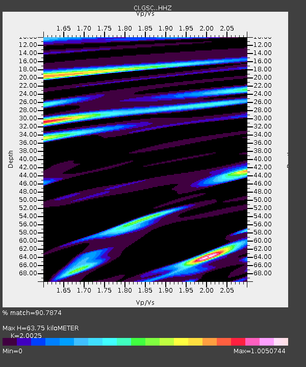
| Estimated Moho Depth: |
63.75 km |
| Estimated Crust Vp/Vs: |
2.00 |
| Assumed Crust Vp: |
6.276 km/s |
| Estimated Crust Vs: |
3.134 km/s |
| Estimated Crust Poisson's Ratio: |
0.33 |
|
| Radial Match: |
90.7874 % |
| Radial Bump: |
400 |
| Transverse Match: |
82.64494 % |
| Transverse Bump: |
400 |
| SOD ConfigId: |
13570011 |
| Insert Time: |
2019-04-28 23:25:57.811 +0000 |
| GWidth: |
2.5 |
| Max Bumps: |
400 |
| Tol: |
0.001 |
|
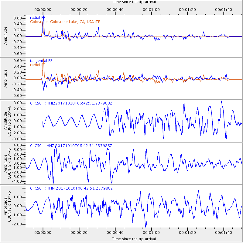
Signal To Noise
| Channel | StoN | STA | LTA |
| CI:GSC: :HHZ:20171010T06:42:51.237988Z | 2.8643355 | 1.6821061E-6 | 5.8725874E-7 |
| CI:GSC: :HHN:20171010T06:42:51.237988Z | 1.6097883 | 6.8664855E-7 | 4.2654588E-7 |
| CI:GSC: :HHE:20171010T06:42:51.237988Z | 1.9318352 | 1.1361212E-6 | 5.881046E-7 |
| Arrivals |
| Ps | 11 SECOND |
| PpPs | 30 SECOND |
| PsPs/PpSs | 40 SECOND |


