You are here: Home > Network List > TA - USArray Transportable Network (new EarthScope stations) Stations List
> Station G13A Cobalt, ID, USA > Earthquake Result Viewer
G13A Cobalt, ID, USA - Earthquake Result Viewer
| Earthquake location: |
Chile-Argentina Border Region |
| Earthquake latitude/longitude: |
-24.8/-68.5 |
| Earthquake time(UTC): |
2007/11/21 (325) 12:55:05 GMT |
| Earthquake Depth: |
115 km |
| Earthquake Magnitude: |
5.6 MB, 5.8 MW, 5.8 MW |
| Earthquake Catalog/Contributor: |
WHDF/NEIC |
|
| Network: |
TA USArray Transportable Network (new EarthScope stations) |
| Station: |
G13A Cobalt, ID, USA |
| Lat/Lon: |
45.09 N/114.23 W |
| Elevation: |
1538 m |
|
| Distance: |
81.1 deg |
| Az: |
329.093 deg |
| Baz: |
138.777 deg |
| Ray Param: |
0.04755161 |
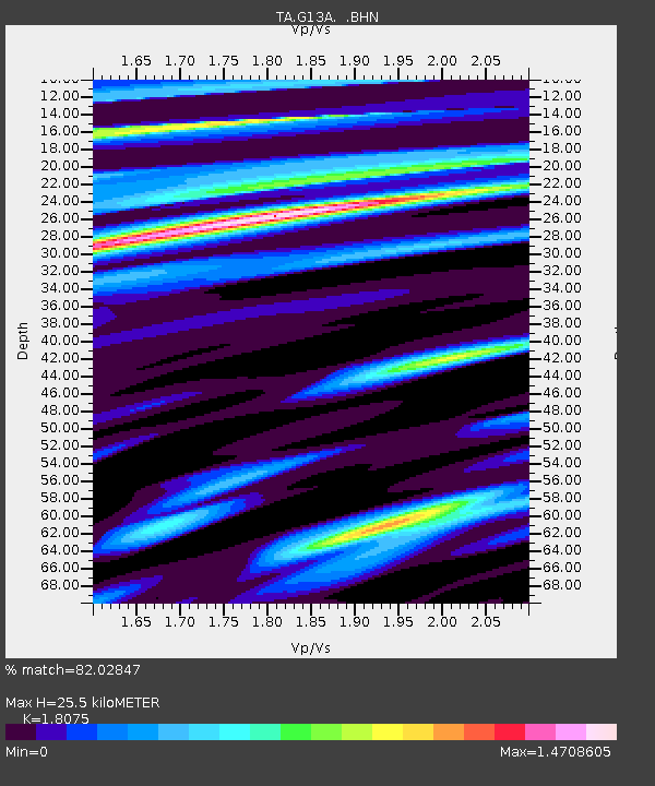
| Estimated Moho Depth: |
25.5 km |
| Estimated Crust Vp/Vs: |
1.81 |
| Assumed Crust Vp: |
6.577 km/s |
| Estimated Crust Vs: |
3.639 km/s |
| Estimated Crust Poisson's Ratio: |
0.28 |
|
| Radial Match: |
82.02847 % |
| Radial Bump: |
400 |
| Transverse Match: |
63.45147 % |
| Transverse Bump: |
400 |
| SOD ConfigId: |
2564 |
| Insert Time: |
2010-03-06 05:11:26.487 +0000 |
| GWidth: |
2.5 |
| Max Bumps: |
400 |
| Tol: |
0.001 |
|
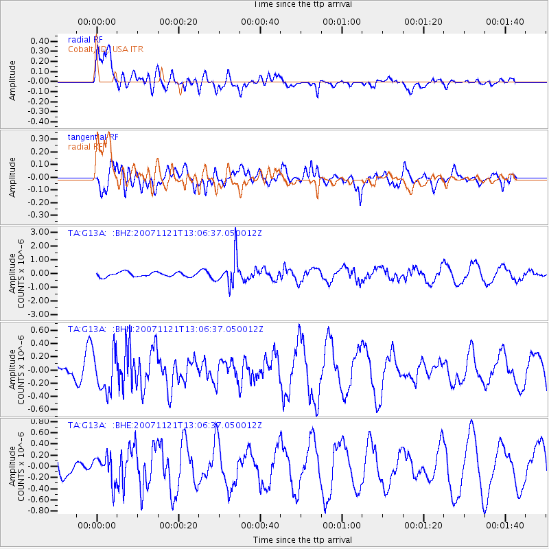
Signal To Noise
| Channel | StoN | STA | LTA |
| TA:G13A: :BHN:20071121T13:06:37.050012Z | 2.8939056 | 3.036315E-7 | 1.0492101E-7 |
| TA:G13A: :BHE:20071121T13:06:37.050012Z | 0.6237719 | 2.4451256E-7 | 3.9199034E-7 |
| TA:G13A: :BHZ:20071121T13:06:37.050012Z | 6.525883 | 1.0650652E-6 | 1.632063E-7 |
| Arrivals |
| Ps | 3.2 SECOND |
| PpPs | 11 SECOND |
| PsPs/PpSs | 14 SECOND |


