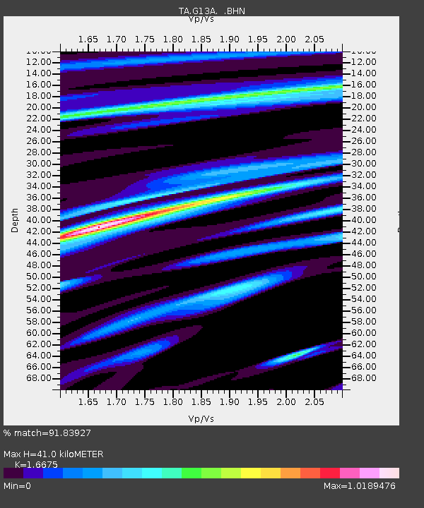
G13A Cobalt, ID, USA - Earthquake Result Viewer
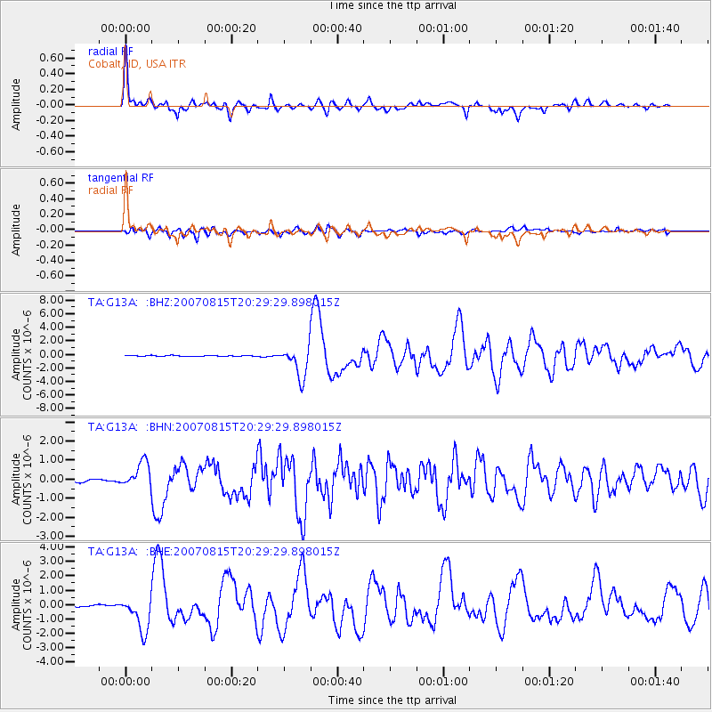
Earthquake location: Andreanof Islands, Aleutian Is.
Earthquake latitude/longitude: 50.3/-177.5
Earthquake time(UTC): 2007/08/15 (227) 20:22:11 GMT
Earthquake Depth: 9.0 km
Earthquake Magnitude: 6.3 MB, 6.2 MS, 6.4 MW, 5.9 ML
Earthquake Catalog/Contributor: WHDF/NEIC
Network: TA USArray Transportable Network (new EarthScope stations)
Station: G13A Cobalt, ID, USA
Lat/Lon: 45.09 N/114.23 W
Elevation: 1538 m
Distance: 41.8 deg
Az: 71.78 deg
Baz: 300.73 deg
Ray Param: 0.07357712
Estimated Moho Depth: 41.0 km
Estimated Crust Vp/Vs: 1.67
Assumed Crust Vp: 6.577 km/s
Estimated Crust Vs: 3.944 km/s
Estimated Crust Poisson's Ratio: 0.22
Radial Match: 91.83927 %
Radial Bump: 400
Transverse Match: 81.75787 %
Transverse Bump: 400
SOD ConfigId: 2564
Insert Time: 2010-03-06 05:11:52.979 +0000
GWidth: 2.5
Max Bumps: 400
Tol: 0.001

Signal To Noise

ChannelStoNSTALTA
TA:G13A: :BHN:20070815T20:29:29.898015Z5.91583446.730086E-71.1376393E-7
TA:G13A: :BHE:20070815T20:29:29.898015Z12.2832491.2221693E-69.949886E-8
TA:G13A: :BHZ:20070815T20:29:29.898015Z34.62752.3252667E-66.715087E-8
Arrivals
Ps4.5 SECOND
PpPs15 SECOND
PsPs/PpSs20 SECOND