You are here: Home > Network List > II - Global Seismograph Network (GSN - IRIS/IDA) Stations List
> Station CMLA Cha de Macela, Sao Miguel Island, Azores > Earthquake Result Viewer
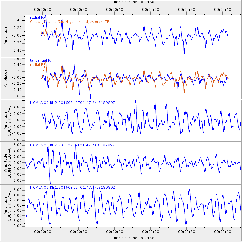
CMLA Cha de Macela, Sao Miguel Island, Azores - Earthquake Result Viewer
*The percent match for this event was below the threshold and hence no stack was calculated.
| Earthquake location: |
Andreanof Islands, Aleutian Is. |
| Earthquake latitude/longitude: |
51.5/-174.2 |
| Earthquake time(UTC): |
2016/03/19 (079) 01:35:12 GMT |
| Earthquake Depth: |
17 km |
| Earthquake Magnitude: |
6.0 MWW, 5.5 ML, 5.8 MWB |
| Earthquake Catalog/Contributor: |
NEIC PDE/NEIC COMCAT |
|
| Network: |
II Global Seismograph Network (GSN - IRIS/IDA) |
| Station: |
CMLA Cha de Macela, Sao Miguel Island, Azores |
| Lat/Lon: |
37.76 N/25.52 W |
| Elevation: |
429 m |
|
| Distance: |
87.0 deg |
| Az: |
24.343 deg |
| Baz: |
341.034 deg |
| Ray Param: |
$rayparam |
*The percent match for this event was below the threshold and hence was not used in the summary stack. |
|
| Radial Match: |
46.6609 % |
| Radial Bump: |
374 |
| Transverse Match: |
65.23947 % |
| Transverse Bump: |
369 |
| SOD ConfigId: |
1464191 |
| Insert Time: |
2016-04-02 02:11:56.549 +0000 |
| GWidth: |
2.5 |
| Max Bumps: |
400 |
| Tol: |
0.001 |
|
Signal To Noise
| Channel | StoN | STA | LTA |
| II:CMLA:00:BHZ:20160319T01:47:24.818989Z | 1.9135846 | 3.1023937E-6 | 1.6212473E-6 |
| II:CMLA:00:BH1:20160319T01:47:24.818989Z | 1.5240628 | 4.5141014E-6 | 2.9618868E-6 |
| II:CMLA:00:BH2:20160319T01:47:24.818989Z | 0.85057306 | 1.7242975E-6 | 2.0272187E-6 |
| Arrivals |
| Ps | |
| PpPs | |
| PsPs/PpSs | |


