You are here: Home > Network List > TA - USArray Transportable Network (new EarthScope stations) Stations List
> Station G13A Cobalt, ID, USA > Earthquake Result Viewer
G13A Cobalt, ID, USA - Earthquake Result Viewer
| Earthquake location: |
Near Coast Of Peru |
| Earthquake latitude/longitude: |
-15.7/-74.9 |
| Earthquake time(UTC): |
2007/06/28 (179) 08:44:48 GMT |
| Earthquake Depth: |
27 km |
| Earthquake Magnitude: |
5.5 MB, 5.3 MS, 5.8 MW, 5.8 MW |
| Earthquake Catalog/Contributor: |
WHDF/NEIC |
|
| Network: |
TA USArray Transportable Network (new EarthScope stations) |
| Station: |
G13A Cobalt, ID, USA |
| Lat/Lon: |
45.09 N/114.23 W |
| Elevation: |
1538 m |
|
| Distance: |
70.2 deg |
| Az: |
331.502 deg |
| Baz: |
139.546 deg |
| Ray Param: |
0.055074032 |
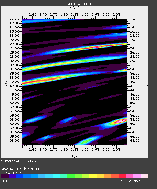
| Estimated Moho Depth: |
58.25 km |
| Estimated Crust Vp/Vs: |
2.08 |
| Assumed Crust Vp: |
6.577 km/s |
| Estimated Crust Vs: |
3.166 km/s |
| Estimated Crust Poisson's Ratio: |
0.35 |
|
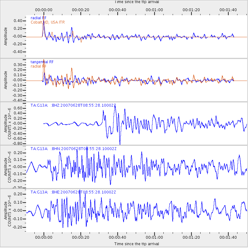
| Radial Match: |
81.507126 % |
| Radial Bump: |
400 |
| Transverse Match: |
70.8572 % |
| Transverse Bump: |
400 |
| SOD ConfigId: |
2564 |
| Insert Time: |
2010-03-06 05:12:12.139 +0000 |
| GWidth: |
2.5 |
| Max Bumps: |
400 |
| Tol: |
0.001 |
|
Signal To Noise
| Channel | StoN | STA | LTA |
| TA:G13A: :BHN:20070628T08:55:28.10002Z | 1.6695627 | 6.031475E-8 | 3.6126075E-8 |
| TA:G13A: :BHE:20070628T08:55:28.10002Z | 1.3797158 | 6.2701865E-8 | 4.5445493E-8 |
| TA:G13A: :BHZ:20070628T08:55:28.10002Z | 7.386019 | 2.6750774E-7 | 3.6218122E-8 |
| Arrivals |
| Ps | 9.9 SECOND |
| PpPs | 26 SECOND |
| PsPs/PpSs | 36 SECOND |


