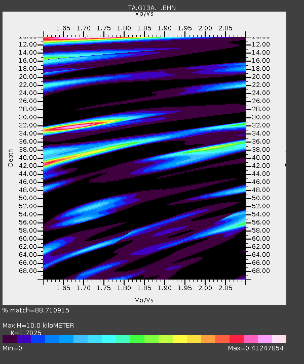
G13A Cobalt, ID, USA - Earthquake Result Viewer
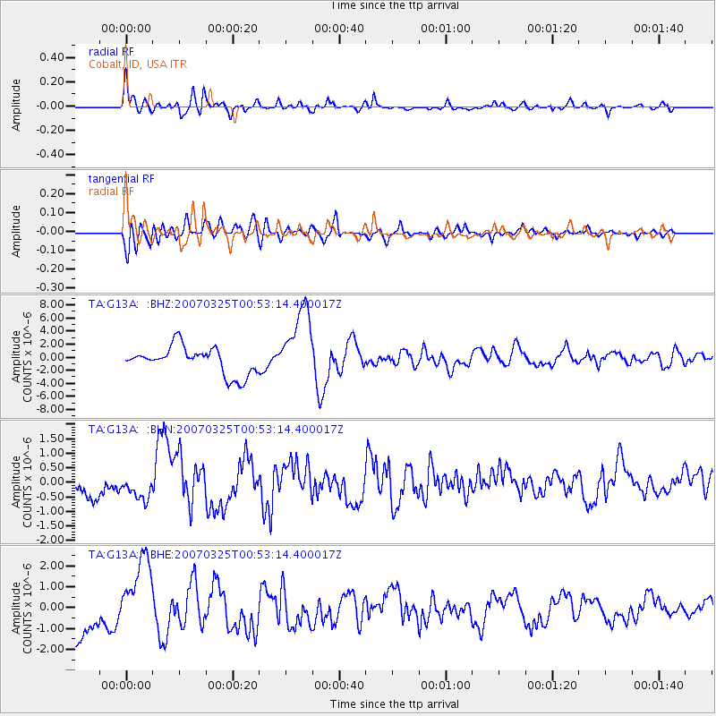
Earthquake location: Near West Coast Of Honshu, Japan
Earthquake latitude/longitude: 37.3/136.6
Earthquake time(UTC): 2007/03/25 (084) 00:41:57 GMT
Earthquake Depth: 8.0 km
Earthquake Magnitude: 6.1 MB, 6.8 MS, 6.7 MW, 6.6 MW
Earthquake Catalog/Contributor: WHDF/NEIC
Network: TA USArray Transportable Network (new EarthScope stations)
Station: G13A Cobalt, ID, USA
Lat/Lon: 45.09 N/114.23 W
Elevation: 1538 m
Distance: 76.1 deg
Az: 43.575 deg
Baz: 309.137 deg
Ray Param: 0.051248845
Estimated Moho Depth: 10.0 km
Estimated Crust Vp/Vs: 1.70
Assumed Crust Vp: 6.577 km/s
Estimated Crust Vs: 3.863 km/s
Estimated Crust Poisson's Ratio: 0.24
Radial Match: 88.710915 %
Radial Bump: 400
Transverse Match: 78.70186 %
Transverse Bump: 400
SOD ConfigId: 2564
Insert Time: 2010-03-06 05:12:18.266 +0000
GWidth: 2.5
Max Bumps: 400
Tol: 0.001

Signal To Noise

ChannelStoNSTALTA
TA:G13A: :BHN:20070325T00:53:14.400017Z1.6504034.055891E-72.4575155E-7
TA:G13A: :BHE:20070325T00:53:14.400017Z2.5312031.8606156E-67.3507164E-7
TA:G13A: :BHZ:20070325T00:53:14.400017Z2.74163725.7494617E-62.0970906E-6
Arrivals
Ps1.1 SECOND
PpPs4.0 SECOND
PsPs/PpSs5.1 SECOND