You are here: Home > Network List > LD - Lamont-Doherty Cooperative Seismographic Network Stations List
> Station MVL Millersville University, PA > Earthquake Result Viewer
MVL Millersville University, PA - Earthquake Result Viewer

| Earthquake location: |
Northern Chile |
| Earthquake latitude/longitude: |
-18.5/-69.6 |
| Earthquake time(UTC): |
2017/10/10 (283) 06:32:20 GMT |
| Earthquake Depth: |
82 km |
| Earthquake Magnitude: |
6.3 Mww |
| Earthquake Catalog/Contributor: |
NEIC PDE/us |
|
| Network: |
LD Lamont-Doherty Cooperative Seismographic Network |
| Station: |
MVL Millersville University, PA |
| Lat/Lon: |
40.00 N/76.35 W |
| Elevation: |
91 m |
|
| Distance: |
58.6 deg |
| Az: |
353.961 deg |
| Baz: |
172.533 deg |
| Ray Param: |
0.062542774 |
| Estimated Moho Depth: |
47.5 km |
| Estimated Crust Vp/Vs: |
1.64 |
| Assumed Crust Vp: |
6.419 km/s |
| Estimated Crust Vs: |
3.914 km/s |
| Estimated Crust Poisson's Ratio: |
0.20 |
|
| Radial Match: |
89.8291 % |
| Radial Bump: |
299 |
| Transverse Match: |
81.739944 % |
| Transverse Bump: |
306 |
| SOD ConfigId: |
13570011 |
| Insert Time: |
2019-04-28 23:28:24.862 +0000 |
| GWidth: |
2.5 |
| Max Bumps: |
400 |
| Tol: |
0.001 |
|
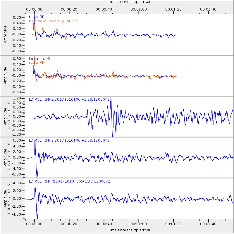
Signal To Noise
| Channel | StoN | STA | LTA |
| LD:MVL: :HHZ:20171010T06:41:38.120007Z | 24.526554 | 3.0643444E-6 | 1.2493987E-7 |
| LD:MVL: :HHN:20171010T06:41:38.120007Z | 14.47501 | 2.0558302E-6 | 1.4202617E-7 |
| LD:MVL: :HHE:20171010T06:41:38.120007Z | 4.26053 | 3.6258731E-7 | 8.510381E-8 |
| Arrivals |
| Ps | 5.0 SECOND |
| PpPs | 19 SECOND |
| PsPs/PpSs | 24 SECOND |


