You are here: Home > Network List > TA - USArray Transportable Network (new EarthScope stations) Stations List
> Station G13A Cobalt, ID, USA > Earthquake Result Viewer
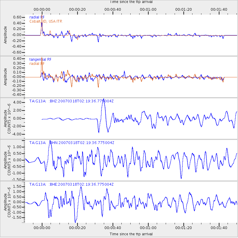
G13A Cobalt, ID, USA - Earthquake Result Viewer
| Earthquake location: |
South Of Panama |
| Earthquake latitude/longitude: |
4.6/-78.5 |
| Earthquake time(UTC): |
2007/03/18 (077) 02:11:05 GMT |
| Earthquake Depth: |
8.0 km |
| Earthquake Magnitude: |
6.4 MB, 5.7 MS, 6.2 MW, 6.1 MW |
| Earthquake Catalog/Contributor: |
WHDF/NEIC |
|
| Network: |
TA USArray Transportable Network (new EarthScope stations) |
| Station: |
G13A Cobalt, ID, USA |
| Lat/Lon: |
45.09 N/114.23 W |
| Elevation: |
1538 m |
|
| Distance: |
51.0 deg |
| Az: |
327.844 deg |
| Baz: |
131.496 deg |
| Ray Param: |
0.067688726 |
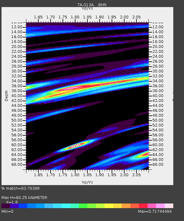
| Estimated Moho Depth: |
60.25 km |
| Estimated Crust Vp/Vs: |
1.80 |
| Assumed Crust Vp: |
6.577 km/s |
| Estimated Crust Vs: |
3.654 km/s |
| Estimated Crust Poisson's Ratio: |
0.28 |
|
| Radial Match: |
83.78389 % |
| Radial Bump: |
400 |
| Transverse Match: |
74.84438 % |
| Transverse Bump: |
400 |
| SOD ConfigId: |
2564 |
| Insert Time: |
2010-03-06 05:12:20.845 +0000 |
| GWidth: |
2.5 |
| Max Bumps: |
400 |
| Tol: |
0.001 |
|
Signal To Noise
| Channel | StoN | STA | LTA |
| TA:G13A: :BHN:20070318T02:19:36.775004Z | 5.658829 | 6.759714E-7 | 1.1945428E-7 |
| TA:G13A: :BHE:20070318T02:19:36.775004Z | 5.2625813 | 6.462329E-7 | 1.2279769E-7 |
| TA:G13A: :BHZ:20070318T02:19:36.775004Z | 17.262224 | 2.2710226E-6 | 1.3156024E-7 |
| Arrivals |
| Ps | 7.8 SECOND |
| PpPs | 24 SECOND |
| PsPs/PpSs | 32 SECOND |


