You are here: Home > Network List > N4 - Central and EAstern US Network Stations List
> Station F63A Nahmakanta, Browneville, ME, USA > Earthquake Result Viewer
F63A Nahmakanta, Browneville, ME, USA - Earthquake Result Viewer
| Earthquake location: |
Northern Chile |
| Earthquake latitude/longitude: |
-18.5/-69.6 |
| Earthquake time(UTC): |
2017/10/10 (283) 06:32:20 GMT |
| Earthquake Depth: |
82 km |
| Earthquake Magnitude: |
6.3 Mww |
| Earthquake Catalog/Contributor: |
NEIC PDE/us |
|
| Network: |
N4 Central and EAstern US Network |
| Station: |
F63A Nahmakanta, Browneville, ME, USA |
| Lat/Lon: |
45.70 N/69.10 W |
| Elevation: |
386 m |
|
| Distance: |
63.9 deg |
| Az: |
0.42 deg |
| Baz: |
180.569 deg |
| Ray Param: |
0.059047267 |
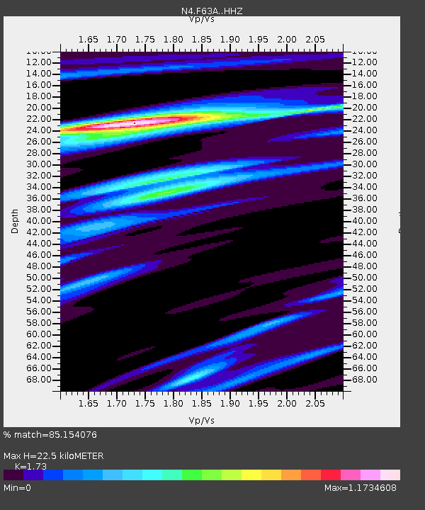
| Estimated Moho Depth: |
22.5 km |
| Estimated Crust Vp/Vs: |
1.73 |
| Assumed Crust Vp: |
6.419 km/s |
| Estimated Crust Vs: |
3.711 km/s |
| Estimated Crust Poisson's Ratio: |
0.25 |
|
| Radial Match: |
85.154076 % |
| Radial Bump: |
304 |
| Transverse Match: |
66.08926 % |
| Transverse Bump: |
312 |
| SOD ConfigId: |
13570011 |
| Insert Time: |
2019-04-28 23:29:05.971 +0000 |
| GWidth: |
2.5 |
| Max Bumps: |
400 |
| Tol: |
0.001 |
|

Signal To Noise
| Channel | StoN | STA | LTA |
| N4:F63A: :HHZ:20171010T06:42:14.269971Z | 15.796474 | 2.5836052E-6 | 1.6355581E-7 |
| N4:F63A: :HHN:20171010T06:42:14.269971Z | 6.6973033 | 1.3715892E-6 | 2.0479723E-7 |
| N4:F63A: :HHE:20171010T06:42:14.269971Z | 2.8473048 | 4.0644954E-7 | 1.4274887E-7 |
| Arrivals |
| Ps | 2.7 SECOND |
| PpPs | 9.2 SECOND |
| PsPs/PpSs | 12 SECOND |


