You are here: Home > Network List > CI - Caltech Regional Seismic Network Stations List
> Station SMM Simmler, CA, USA > Earthquake Result Viewer
SMM Simmler, CA, USA - Earthquake Result Viewer
*The percent match for this event was below the threshold and hence no stack was calculated.
| Earthquake location: |
Kuril Islands |
| Earthquake latitude/longitude: |
49.9/156.4 |
| Earthquake time(UTC): |
2008/08/04 (217) 04:42:14 GMT |
| Earthquake Depth: |
77 km |
| Earthquake Magnitude: |
5.6 MB, 5.8 MW, 5.7 MW |
| Earthquake Catalog/Contributor: |
WHDF/NEIC |
|
| Network: |
CI Caltech Regional Seismic Network |
| Station: |
SMM Simmler, CA, USA |
| Lat/Lon: |
35.31 N/120.00 W |
| Elevation: |
599 m |
|
| Distance: |
60.2 deg |
| Az: |
69.537 deg |
| Baz: |
312.137 deg |
| Ray Param: |
$rayparam |
*The percent match for this event was below the threshold and hence was not used in the summary stack. |
|
| Radial Match: |
61.10497 % |
| Radial Bump: |
400 |
| Transverse Match: |
69.610535 % |
| Transverse Bump: |
400 |
| SOD ConfigId: |
2504 |
| Insert Time: |
2010-02-26 01:31:59.951 +0000 |
| GWidth: |
2.5 |
| Max Bumps: |
400 |
| Tol: |
0.001 |
|
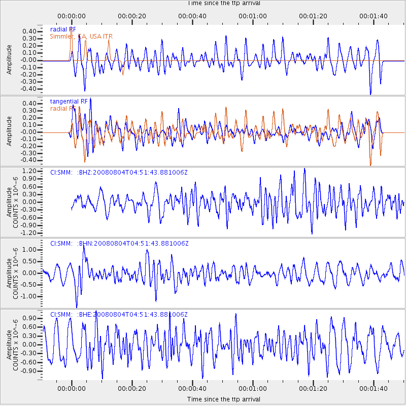
Signal To Noise
| Channel | StoN | STA | LTA |
| CI:SMM: :BHN:20080804T04:51:43.881006Z | 2.6735704 | 6.7132817E-7 | 2.51098E-7 |
| CI:SMM: :BHE:20080804T04:51:43.881006Z | 1.296837 | 5.32167E-7 | 4.103577E-7 |
| CI:SMM: :BHZ:20080804T04:51:43.881006Z | 1.4881175 | 3.5136154E-7 | 2.3611143E-7 |
| Arrivals |
| Ps | |
| PpPs | |
| PsPs/PpSs | |


