You are here: Home > Network List > N4 - Central and EAstern US Network Stations List
> Station F64A Sherman, ME, USA > Earthquake Result Viewer
F64A Sherman, ME, USA - Earthquake Result Viewer
| Earthquake location: |
Northern Chile |
| Earthquake latitude/longitude: |
-18.5/-69.6 |
| Earthquake time(UTC): |
2017/10/10 (283) 06:32:20 GMT |
| Earthquake Depth: |
82 km |
| Earthquake Magnitude: |
6.3 Mww |
| Earthquake Catalog/Contributor: |
NEIC PDE/us |
|
| Network: |
N4 Central and EAstern US Network |
| Station: |
F64A Sherman, ME, USA |
| Lat/Lon: |
45.86 N/68.35 W |
| Elevation: |
179 m |
|
| Distance: |
64.1 deg |
| Az: |
1.003 deg |
| Baz: |
181.362 deg |
| Ray Param: |
0.05893908 |
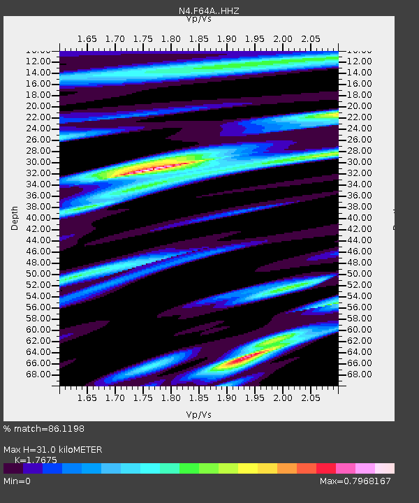
| Estimated Moho Depth: |
31.0 km |
| Estimated Crust Vp/Vs: |
1.77 |
| Assumed Crust Vp: |
6.419 km/s |
| Estimated Crust Vs: |
3.632 km/s |
| Estimated Crust Poisson's Ratio: |
0.26 |
|
| Radial Match: |
86.1198 % |
| Radial Bump: |
305 |
| Transverse Match: |
70.267426 % |
| Transverse Bump: |
400 |
| SOD ConfigId: |
13570011 |
| Insert Time: |
2019-04-28 23:29:06.469 +0000 |
| GWidth: |
2.5 |
| Max Bumps: |
400 |
| Tol: |
0.001 |
|

Signal To Noise
| Channel | StoN | STA | LTA |
| N4:F64A: :HHZ:20171010T06:42:15.380017Z | 15.761208 | 3.9450138E-6 | 2.5029894E-7 |
| N4:F64A: :HHN:20171010T06:42:15.380017Z | 13.322184 | 1.855007E-6 | 1.3924196E-7 |
| N4:F64A: :HHE:20171010T06:42:15.380017Z | 3.7459564 | 5.793329E-7 | 1.5465552E-7 |
| Arrivals |
| Ps | 3.9 SECOND |
| PpPs | 13 SECOND |
| PsPs/PpSs | 17 SECOND |


