You are here: Home > Network List > TA - USArray Transportable Network (new EarthScope stations) Stations List
> Station G13A Cobalt, ID, USA > Earthquake Result Viewer
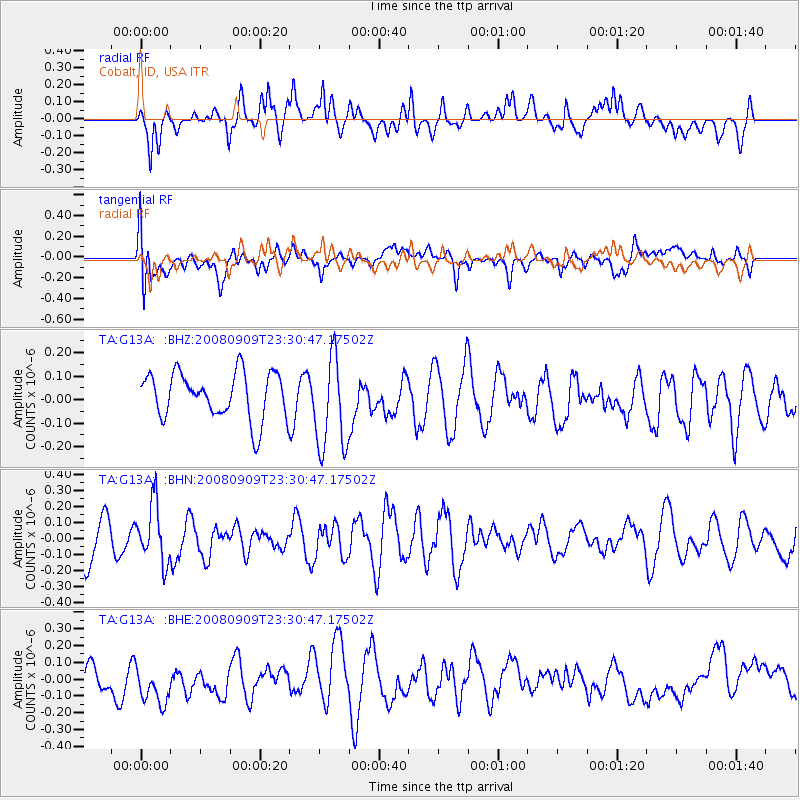
G13A Cobalt, ID, USA - Earthquake Result Viewer
*The percent match for this event was below the threshold and hence no stack was calculated.
| Earthquake location: |
Santa Cruz Islands |
| Earthquake latitude/longitude: |
-11.8/166.5 |
| Earthquake time(UTC): |
2008/09/09 (253) 23:18:26 GMT |
| Earthquake Depth: |
99 km |
| Earthquake Magnitude: |
5.6 MW, 5.4 MB, 5.6 MW |
| Earthquake Catalog/Contributor: |
WHDF/NEIC |
|
| Network: |
TA USArray Transportable Network (new EarthScope stations) |
| Station: |
G13A Cobalt, ID, USA |
| Lat/Lon: |
45.09 N/114.23 W |
| Elevation: |
1538 m |
|
| Distance: |
90.8 deg |
| Az: |
44.106 deg |
| Baz: |
254.171 deg |
| Ray Param: |
$rayparam |
*The percent match for this event was below the threshold and hence was not used in the summary stack. |
|
| Radial Match: |
52.294407 % |
| Radial Bump: |
400 |
| Transverse Match: |
50.74082 % |
| Transverse Bump: |
400 |
| SOD ConfigId: |
2560 |
| Insert Time: |
2010-03-06 05:12:48.520 +0000 |
| GWidth: |
2.5 |
| Max Bumps: |
400 |
| Tol: |
0.001 |
|
Signal To Noise
| Channel | StoN | STA | LTA |
| TA:G13A: :BHN:20080909T23:30:47.17502Z | 1.6102726 | 1.8102533E-7 | 1.1241906E-7 |
| TA:G13A: :BHE:20080909T23:30:47.17502Z | 1.1392128 | 1.4117774E-7 | 1.2392569E-7 |
| TA:G13A: :BHZ:20080909T23:30:47.17502Z | 2.0616753 | 2.0207685E-7 | 9.8015846E-8 |
| Arrivals |
| Ps | |
| PpPs | |
| PsPs/PpSs | |


