You are here: Home > Network List > TA - USArray Transportable Network (new EarthScope stations) Stations List
> Station G13A Cobalt, ID, USA > Earthquake Result Viewer
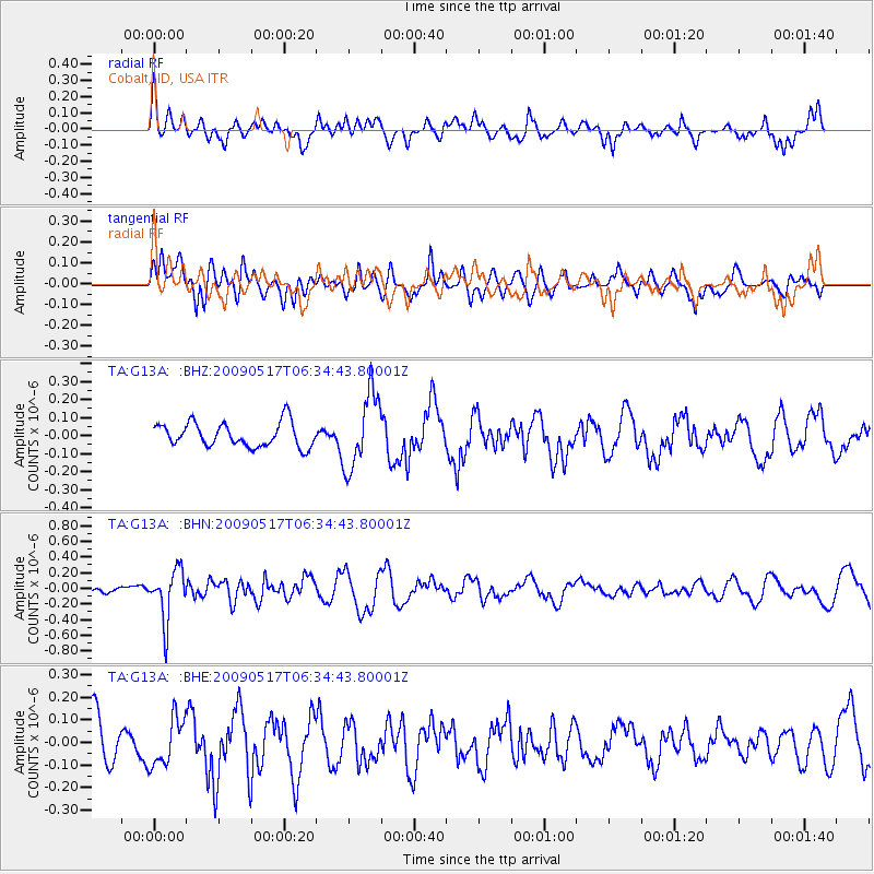
G13A Cobalt, ID, USA - Earthquake Result Viewer
*The percent match for this event was below the threshold and hence no stack was calculated.
| Earthquake location: |
Tonga Islands |
| Earthquake latitude/longitude: |
-16.8/-173.5 |
| Earthquake time(UTC): |
2009/05/17 (137) 06:23:03 GMT |
| Earthquake Depth: |
67 km |
| Earthquake Magnitude: |
5.5 MB, 5.6 MW, 5.6 MW |
| Earthquake Catalog/Contributor: |
WHDF/NEIC |
|
| Network: |
TA USArray Transportable Network (new EarthScope stations) |
| Station: |
G13A Cobalt, ID, USA |
| Lat/Lon: |
45.09 N/114.23 W |
| Elevation: |
1538 m |
|
| Distance: |
81.7 deg |
| Az: |
37.965 deg |
| Baz: |
236.282 deg |
| Ray Param: |
$rayparam |
*The percent match for this event was below the threshold and hence was not used in the summary stack. |
|
| Radial Match: |
42.590942 % |
| Radial Bump: |
400 |
| Transverse Match: |
55.890877 % |
| Transverse Bump: |
400 |
| SOD ConfigId: |
2760 |
| Insert Time: |
2010-03-06 05:12:57.487 +0000 |
| GWidth: |
2.5 |
| Max Bumps: |
400 |
| Tol: |
0.001 |
|
Signal To Noise
| Channel | StoN | STA | LTA |
| TA:G13A: :BHN:20090517T06:34:43.80001Z | 2.6883159 | 3.2234868E-7 | 1.1990728E-7 |
| TA:G13A: :BHE:20090517T06:34:43.80001Z | 1.0054979 | 1.0527526E-7 | 1.0469963E-7 |
| TA:G13A: :BHZ:20090517T06:34:43.80001Z | 3.111214 | 2.0771658E-7 | 6.676384E-8 |
| Arrivals |
| Ps | |
| PpPs | |
| PsPs/PpSs | |


