You are here: Home > Network List > TA - USArray Transportable Network (new EarthScope stations) Stations List
> Station G13A Cobalt, ID, USA > Earthquake Result Viewer
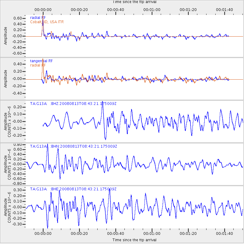
G13A Cobalt, ID, USA - Earthquake Result Viewer
*The percent match for this event was below the threshold and hence no stack was calculated.
| Earthquake location: |
North Of Severnaya Zemlya |
| Earthquake latitude/longitude: |
83.6/115.2 |
| Earthquake time(UTC): |
2008/08/13 (226) 08:35:02 GMT |
| Earthquake Depth: |
10 km |
| Earthquake Magnitude: |
5.5 MB, 4.7 MS, 5.4 MW, 5.4 MW |
| Earthquake Catalog/Contributor: |
WHDF/NEIC |
|
| Network: |
TA USArray Transportable Network (new EarthScope stations) |
| Station: |
G13A Cobalt, ID, USA |
| Lat/Lon: |
45.09 N/114.23 W |
| Elevation: |
1538 m |
|
| Distance: |
49.4 deg |
| Az: |
45.127 deg |
| Baz: |
353.595 deg |
| Ray Param: |
$rayparam |
*The percent match for this event was below the threshold and hence was not used in the summary stack. |
|
| Radial Match: |
78.59697 % |
| Radial Bump: |
400 |
| Transverse Match: |
56.207916 % |
| Transverse Bump: |
388 |
| SOD ConfigId: |
2504 |
| Insert Time: |
2010-03-06 05:13:00.011 +0000 |
| GWidth: |
2.5 |
| Max Bumps: |
400 |
| Tol: |
0.001 |
|
Signal To Noise
| Channel | StoN | STA | LTA |
| TA:G13A: :BHN:20080813T08:43:21.175009Z | 4.8432693 | 2.9601952E-7 | 6.111977E-8 |
| TA:G13A: :BHE:20080813T08:43:21.175009Z | 3.8524287 | 1.4624439E-7 | 3.796161E-8 |
| TA:G13A: :BHZ:20080813T08:43:21.175009Z | 2.5793085 | 1.3952861E-7 | 5.409536E-8 |
| Arrivals |
| Ps | |
| PpPs | |
| PsPs/PpSs | |


