You are here: Home > Network List > N4 - Central and EAstern US Network Stations List
> Station T60A Surry, VA, USA > Earthquake Result Viewer
T60A Surry, VA, USA - Earthquake Result Viewer
| Earthquake location: |
Northern Chile |
| Earthquake latitude/longitude: |
-18.5/-69.6 |
| Earthquake time(UTC): |
2017/10/10 (283) 06:32:20 GMT |
| Earthquake Depth: |
82 km |
| Earthquake Magnitude: |
6.3 Mww |
| Earthquake Catalog/Contributor: |
NEIC PDE/us |
|
| Network: |
N4 Central and EAstern US Network |
| Station: |
T60A Surry, VA, USA |
| Lat/Lon: |
37.14 N/76.73 W |
| Elevation: |
11 m |
|
| Distance: |
55.8 deg |
| Az: |
353.144 deg |
| Baz: |
171.852 deg |
| Ray Param: |
0.06434501 |
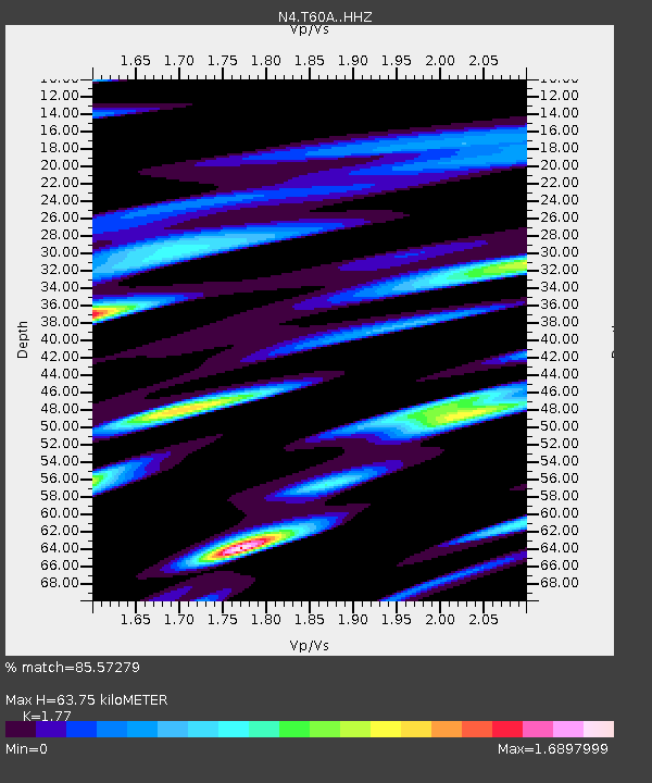
| Estimated Moho Depth: |
63.75 km |
| Estimated Crust Vp/Vs: |
1.77 |
| Assumed Crust Vp: |
6.565 km/s |
| Estimated Crust Vs: |
3.709 km/s |
| Estimated Crust Poisson's Ratio: |
0.27 |
|
| Radial Match: |
85.57279 % |
| Radial Bump: |
333 |
| Transverse Match: |
73.89271 % |
| Transverse Bump: |
339 |
| SOD ConfigId: |
13570011 |
| Insert Time: |
2019-04-28 23:30:11.159 +0000 |
| GWidth: |
2.5 |
| Max Bumps: |
400 |
| Tol: |
0.001 |
|

Signal To Noise
| Channel | StoN | STA | LTA |
| N4:T60A: :HHZ:20171010T06:41:18.519971Z | 16.901121 | 3.5166909E-6 | 2.0807441E-7 |
| N4:T60A: :HHN:20171010T06:41:18.519971Z | 7.850549 | 5.277584E-6 | 6.7225665E-7 |
| N4:T60A: :HHE:20171010T06:41:18.519971Z | 3.7634826 | 1.7672434E-6 | 4.6957663E-7 |
| Arrivals |
| Ps | 7.9 SECOND |
| PpPs | 25 SECOND |
| PsPs/PpSs | 33 SECOND |


