You are here: Home > Network List > N4 - Central and EAstern US Network Stations List
> Station Z51A Franklin, GA, USA > Earthquake Result Viewer
Z51A Franklin, GA, USA - Earthquake Result Viewer
| Earthquake location: |
Northern Chile |
| Earthquake latitude/longitude: |
-18.5/-69.6 |
| Earthquake time(UTC): |
2017/10/10 (283) 06:32:20 GMT |
| Earthquake Depth: |
82 km |
| Earthquake Magnitude: |
6.3 Mww |
| Earthquake Catalog/Contributor: |
NEIC PDE/us |
|
| Network: |
N4 Central and EAstern US Network |
| Station: |
Z51A Franklin, GA, USA |
| Lat/Lon: |
33.32 N/85.17 W |
| Elevation: |
249 m |
|
| Distance: |
53.6 deg |
| Az: |
343.832 deg |
| Baz: |
161.607 deg |
| Ray Param: |
0.065714866 |
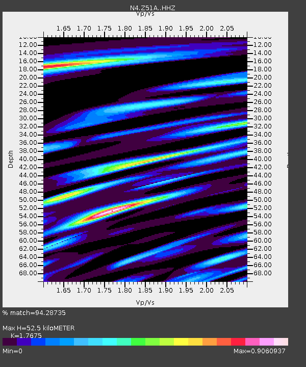
| Estimated Moho Depth: |
52.5 km |
| Estimated Crust Vp/Vs: |
1.77 |
| Assumed Crust Vp: |
6.719 km/s |
| Estimated Crust Vs: |
3.802 km/s |
| Estimated Crust Poisson's Ratio: |
0.26 |
|
| Radial Match: |
94.28735 % |
| Radial Bump: |
302 |
| Transverse Match: |
77.741234 % |
| Transverse Bump: |
400 |
| SOD ConfigId: |
13570011 |
| Insert Time: |
2019-04-28 23:30:29.522 +0000 |
| GWidth: |
2.5 |
| Max Bumps: |
400 |
| Tol: |
0.001 |
|

Signal To Noise
| Channel | StoN | STA | LTA |
| N4:Z51A: :HHZ:20171010T06:41:03.200024Z | 39.883175 | 3.4766128E-6 | 8.7169916E-8 |
| N4:Z51A: :HHN:20171010T06:41:03.200024Z | 25.328878 | 2.1856904E-6 | 8.6292424E-8 |
| N4:Z51A: :HHE:20171010T06:41:03.200024Z | 11.858463 | 8.979817E-7 | 7.572496E-8 |
| Arrivals |
| Ps | 6.4 SECOND |
| PpPs | 20 SECOND |
| PsPs/PpSs | 27 SECOND |


