You are here: Home > Network List > OK - Oklahoma Seismic Network Stations List
> Station X37A Clayton, Oklahoma, USA > Earthquake Result Viewer
X37A Clayton, Oklahoma, USA - Earthquake Result Viewer
| Earthquake location: |
Northern Chile |
| Earthquake latitude/longitude: |
-18.5/-69.6 |
| Earthquake time(UTC): |
2017/10/10 (283) 06:32:20 GMT |
| Earthquake Depth: |
82 km |
| Earthquake Magnitude: |
6.3 Mww |
| Earthquake Catalog/Contributor: |
NEIC PDE/us |
|
| Network: |
OK Oklahoma Seismic Network |
| Station: |
X37A Clayton, Oklahoma, USA |
| Lat/Lon: |
34.59 N/95.37 W |
| Elevation: |
207 m |
|
| Distance: |
58.2 deg |
| Az: |
335.079 deg |
| Baz: |
151.013 deg |
| Ray Param: |
0.062762596 |
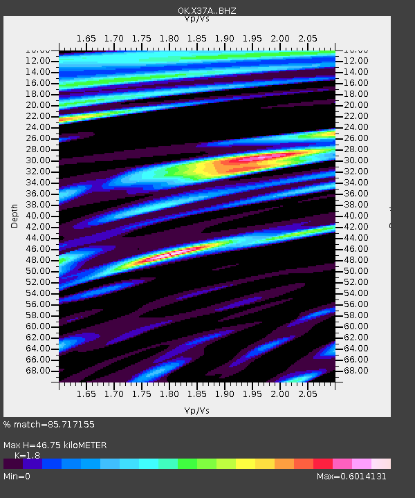
| Estimated Moho Depth: |
46.75 km |
| Estimated Crust Vp/Vs: |
1.80 |
| Assumed Crust Vp: |
6.498 km/s |
| Estimated Crust Vs: |
3.61 km/s |
| Estimated Crust Poisson's Ratio: |
0.28 |
|
| Radial Match: |
85.717155 % |
| Radial Bump: |
400 |
| Transverse Match: |
83.33074 % |
| Transverse Bump: |
400 |
| SOD ConfigId: |
13570011 |
| Insert Time: |
2019-04-28 23:31:40.118 +0000 |
| GWidth: |
2.5 |
| Max Bumps: |
400 |
| Tol: |
0.001 |
|

Signal To Noise
| Channel | StoN | STA | LTA |
| OK:X37A: :BHZ:20171010T06:41:35.774976Z | 16.50274 | 5.731315E-6 | 3.4729473E-7 |
| OK:X37A: :BHN:20171010T06:41:35.774976Z | 4.2280254 | 1.0217775E-6 | 2.4166775E-7 |
| OK:X37A: :BHE:20171010T06:41:35.774976Z | 2.401856 | 5.2232934E-7 | 2.1746906E-7 |
| Arrivals |
| Ps | 6.0 SECOND |
| PpPs | 19 SECOND |
| PsPs/PpSs | 25 SECOND |


