You are here: Home > Network List > TA - USArray Transportable Network (new EarthScope stations) Stations List
> Station G13A Cobalt, ID, USA > Earthquake Result Viewer
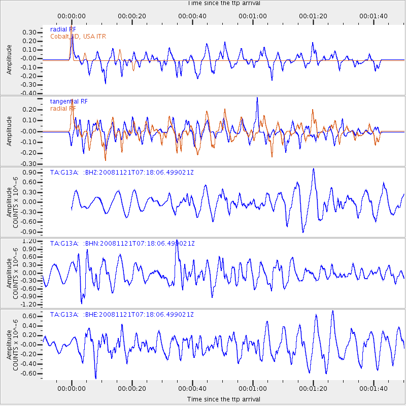
G13A Cobalt, ID, USA - Earthquake Result Viewer
*The percent match for this event was below the threshold and hence no stack was calculated.
| Earthquake location: |
Solomon Islands |
| Earthquake latitude/longitude: |
-8.9/159.6 |
| Earthquake time(UTC): |
2008/11/21 (326) 07:05:34 GMT |
| Earthquake Depth: |
118 km |
| Earthquake Magnitude: |
6.0 MB, 6.1 MW, 6.0 MW |
| Earthquake Catalog/Contributor: |
WHDF/NEIC |
|
| Network: |
TA USArray Transportable Network (new EarthScope stations) |
| Station: |
G13A Cobalt, ID, USA |
| Lat/Lon: |
45.09 N/114.23 W |
| Elevation: |
1538 m |
|
| Distance: |
93.6 deg |
| Az: |
45.088 deg |
| Baz: |
261.037 deg |
| Ray Param: |
$rayparam |
*The percent match for this event was below the threshold and hence was not used in the summary stack. |
|
| Radial Match: |
72.082756 % |
| Radial Bump: |
400 |
| Transverse Match: |
68.57405 % |
| Transverse Bump: |
400 |
| SOD ConfigId: |
2658 |
| Insert Time: |
2010-03-06 05:13:41.691 +0000 |
| GWidth: |
2.5 |
| Max Bumps: |
400 |
| Tol: |
0.001 |
|
Signal To Noise
| Channel | StoN | STA | LTA |
| TA:G13A: :BHN:20081121T07:18:06.499021Z | 3.3304434 | 5.5922106E-7 | 1.6791189E-7 |
| TA:G13A: :BHE:20081121T07:18:06.499021Z | 0.9352714 | 1.7208231E-7 | 1.8399184E-7 |
| TA:G13A: :BHZ:20081121T07:18:06.499021Z | 0.7834212 | 1.7042554E-7 | 2.1754012E-7 |
| Arrivals |
| Ps | |
| PpPs | |
| PsPs/PpSs | |


