You are here: Home > Network List > TA - USArray Transportable Network (new EarthScope stations) Stations List
> Station G13A Cobalt, ID, USA > Earthquake Result Viewer
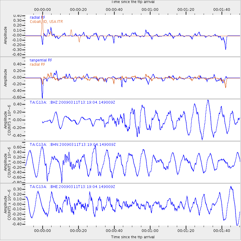
G13A Cobalt, ID, USA - Earthquake Result Viewer
*The percent match for this event was below the threshold and hence no stack was calculated.
| Earthquake location: |
San Juan Province, Argentina |
| Earthquake latitude/longitude: |
-31.9/-69.2 |
| Earthquake time(UTC): |
2009/03/11 (070) 13:06:53 GMT |
| Earthquake Depth: |
28 km |
| Earthquake Magnitude: |
5.5 MB, 4.8 MS, 5.3 MW, 5.5 ML |
| Earthquake Catalog/Contributor: |
WHDF/NEIC |
|
| Network: |
TA USArray Transportable Network (new EarthScope stations) |
| Station: |
G13A Cobalt, ID, USA |
| Lat/Lon: |
45.09 N/114.23 W |
| Elevation: |
1538 m |
|
| Distance: |
86.9 deg |
| Az: |
329.868 deg |
| Baz: |
142.922 deg |
| Ray Param: |
$rayparam |
*The percent match for this event was below the threshold and hence was not used in the summary stack. |
|
| Radial Match: |
47.701923 % |
| Radial Bump: |
400 |
| Transverse Match: |
74.39948 % |
| Transverse Bump: |
400 |
| SOD ConfigId: |
2658 |
| Insert Time: |
2010-03-06 05:13:53.421 +0000 |
| GWidth: |
2.5 |
| Max Bumps: |
400 |
| Tol: |
0.001 |
|
Signal To Noise
| Channel | StoN | STA | LTA |
| TA:G13A: :BHN:20090311T13:19:04.149009Z | 1.3373258 | 4.2002844E-7 | 3.1408086E-7 |
| TA:G13A: :BHE:20090311T13:19:04.149009Z | 0.7958821 | 1.3202262E-7 | 1.6588214E-7 |
| TA:G13A: :BHZ:20090311T13:19:04.149009Z | 0.61210394 | 5.1693522E-8 | 8.4452196E-8 |
| Arrivals |
| Ps | |
| PpPs | |
| PsPs/PpSs | |


