You are here: Home > Network List > CI - Caltech Regional Seismic Network Stations List
> Station SMM Simmler, CA, USA > Earthquake Result Viewer
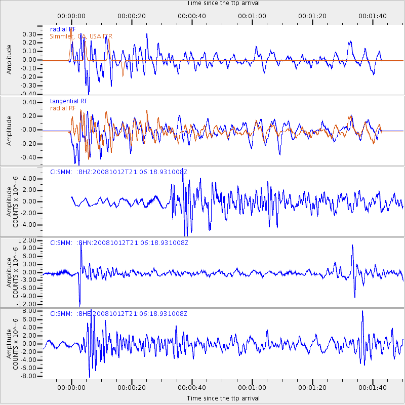
SMM Simmler, CA, USA - Earthquake Result Viewer
*The percent match for this event was below the threshold and hence no stack was calculated.
| Earthquake location: |
Southern Bolivia |
| Earthquake latitude/longitude: |
-20.1/-65.0 |
| Earthquake time(UTC): |
2008/10/12 (286) 20:55:41 GMT |
| Earthquake Depth: |
353 km |
| Earthquake Magnitude: |
6.0 MB, 6.2 MW, 6.2 MW |
| Earthquake Catalog/Contributor: |
WHDF/NEIC |
|
| Network: |
CI Caltech Regional Seismic Network |
| Station: |
SMM Simmler, CA, USA |
| Lat/Lon: |
35.31 N/120.00 W |
| Elevation: |
599 m |
|
| Distance: |
75.9 deg |
| Az: |
316.294 deg |
| Baz: |
127.446 deg |
| Ray Param: |
$rayparam |
*The percent match for this event was below the threshold and hence was not used in the summary stack. |
|
| Radial Match: |
66.38985 % |
| Radial Bump: |
400 |
| Transverse Match: |
69.208534 % |
| Transverse Bump: |
400 |
| SOD ConfigId: |
2556 |
| Insert Time: |
2010-02-26 01:32:04.867 +0000 |
| GWidth: |
2.5 |
| Max Bumps: |
400 |
| Tol: |
0.001 |
|
Signal To Noise
| Channel | StoN | STA | LTA |
| CI:SMM: :BHN:20081012T21:06:18.931008Z | 5.9824057 | 3.676033E-6 | 6.1447406E-7 |
| CI:SMM: :BHE:20081012T21:06:18.931008Z | 0.9674199 | 8.124073E-7 | 8.39767E-7 |
| CI:SMM: :BHZ:20081012T21:06:18.931008Z | 2.686829 | 1.2544265E-6 | 4.668799E-7 |
| Arrivals |
| Ps | |
| PpPs | |
| PsPs/PpSs | |


